You are here: Home > Network List > TA - USArray Transportable Network (new EarthScope stations) Stations List
> Station E20K Nigu River, AK, USA > Earthquake Result Viewer
E20K Nigu River, AK, USA - Earthquake Result Viewer
*The percent match for this event was below the threshold and hence no stack was calculated.
| Earthquake location: |
Tajikistan |
| Earthquake latitude/longitude: |
39.1/71.5 |
| Earthquake time(UTC): |
2020/01/24 (024) 07:09:15 GMT |
| Earthquake Depth: |
10 km |
| Earthquake Magnitude: |
5.5 Mww |
| Earthquake Catalog/Contributor: |
NEIC PDE/us |
|
| Network: |
TA USArray Transportable Network (new EarthScope stations) |
| Station: |
E20K Nigu River, AK, USA |
| Lat/Lon: |
68.26 N/156.19 W |
| Elevation: |
866 m |
|
| Distance: |
67.1 deg |
| Az: |
17.403 deg |
| Baz: |
321.372 deg |
| Ray Param: |
$rayparam |
*The percent match for this event was below the threshold and hence was not used in the summary stack. |
|
| Radial Match: |
50.30283 % |
| Radial Bump: |
400 |
| Transverse Match: |
38.027184 % |
| Transverse Bump: |
400 |
| SOD ConfigId: |
20465011 |
| Insert Time: |
2020-02-07 07:20:36.407 +0000 |
| GWidth: |
2.5 |
| Max Bumps: |
400 |
| Tol: |
0.001 |
|
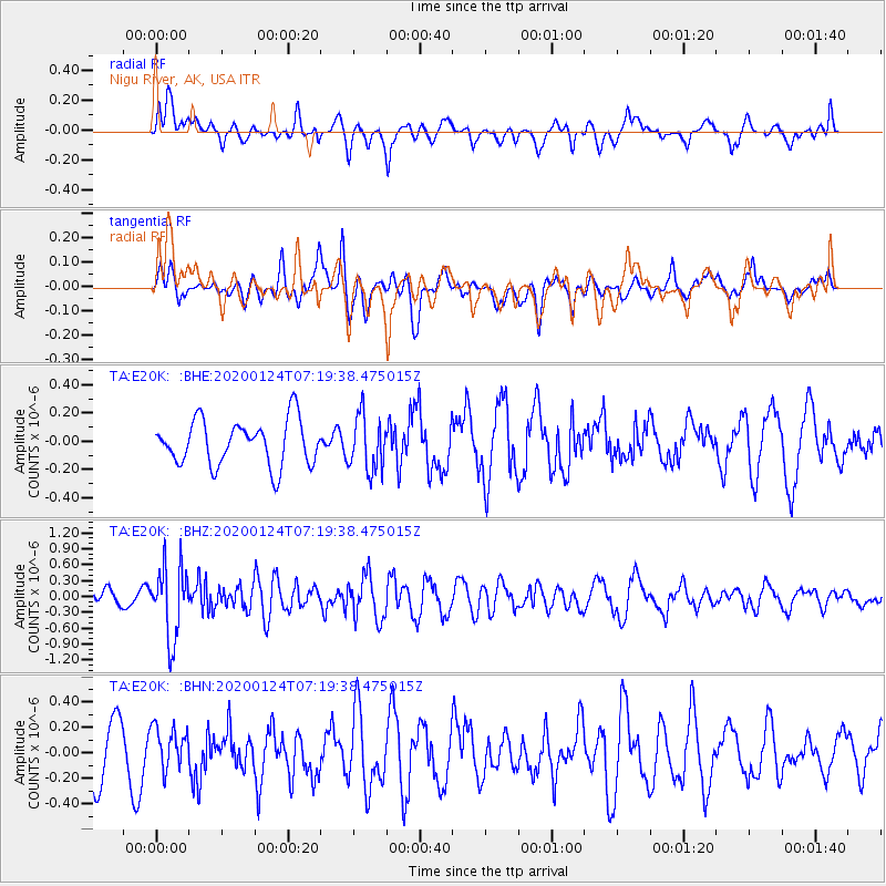
Signal To Noise
| Channel | StoN | STA | LTA |
| TA:E20K: :BHZ:20200124T07:19:38.475015Z | 3.1878202 | 6.742987E-7 | 2.1152344E-7 |
| TA:E20K: :BHN:20200124T07:19:38.475015Z | 0.7689633 | 1.6357663E-7 | 2.1272359E-7 |
| TA:E20K: :BHE:20200124T07:19:38.475015Z | 1.2359875 | 1.9645711E-7 | 1.5894749E-7 |
| Arrivals |
| Ps | |
| PpPs | |
| PsPs/PpSs | |


