You are here: Home > Network List > TA - USArray Transportable Network (new EarthScope stations) Stations List
> Station I30M Mount Dempster, Yukon, CAN > Earthquake Result Viewer
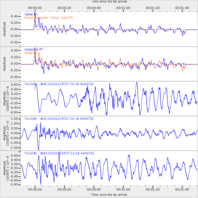
I30M Mount Dempster, Yukon, CAN - Earthquake Result Viewer
*The percent match for this event was below the threshold and hence no stack was calculated.
| Earthquake location: |
Tajikistan |
| Earthquake latitude/longitude: |
39.1/71.5 |
| Earthquake time(UTC): |
2020/01/24 (024) 07:09:15 GMT |
| Earthquake Depth: |
10 km |
| Earthquake Magnitude: |
5.5 Mww |
| Earthquake Catalog/Contributor: |
NEIC PDE/us |
|
| Network: |
TA USArray Transportable Network (new EarthScope stations) |
| Station: |
I30M Mount Dempster, Yukon, CAN |
| Lat/Lon: |
65.22 N/136.38 W |
| Elevation: |
1399 m |
|
| Distance: |
73.7 deg |
| Az: |
11.853 deg |
| Baz: |
337.725 deg |
| Ray Param: |
$rayparam |
*The percent match for this event was below the threshold and hence was not used in the summary stack. |
|
| Radial Match: |
59.196426 % |
| Radial Bump: |
400 |
| Transverse Match: |
49.443855 % |
| Transverse Bump: |
370 |
| SOD ConfigId: |
20465011 |
| Insert Time: |
2020-02-07 07:21:33.863 +0000 |
| GWidth: |
2.5 |
| Max Bumps: |
400 |
| Tol: |
0.001 |
|
Signal To Noise
| Channel | StoN | STA | LTA |
| TA:I30M: :BHZ:20200124T07:20:18.499979Z | 2.1652284 | 7.401429E-7 | 3.4183134E-7 |
| TA:I30M: :BHN:20200124T07:20:18.499979Z | 1.3981634 | 3.2763245E-7 | 2.3433059E-7 |
| TA:I30M: :BHE:20200124T07:20:18.499979Z | 0.70487034 | 1.8595703E-7 | 2.6381736E-7 |
| Arrivals |
| Ps | |
| PpPs | |
| PsPs/PpSs | |


