You are here: Home > Network List > GS - US Geological Survey Networks Stations List
> Station KAN08 Pence Farm, Harper, KS, USA > Earthquake Result Viewer
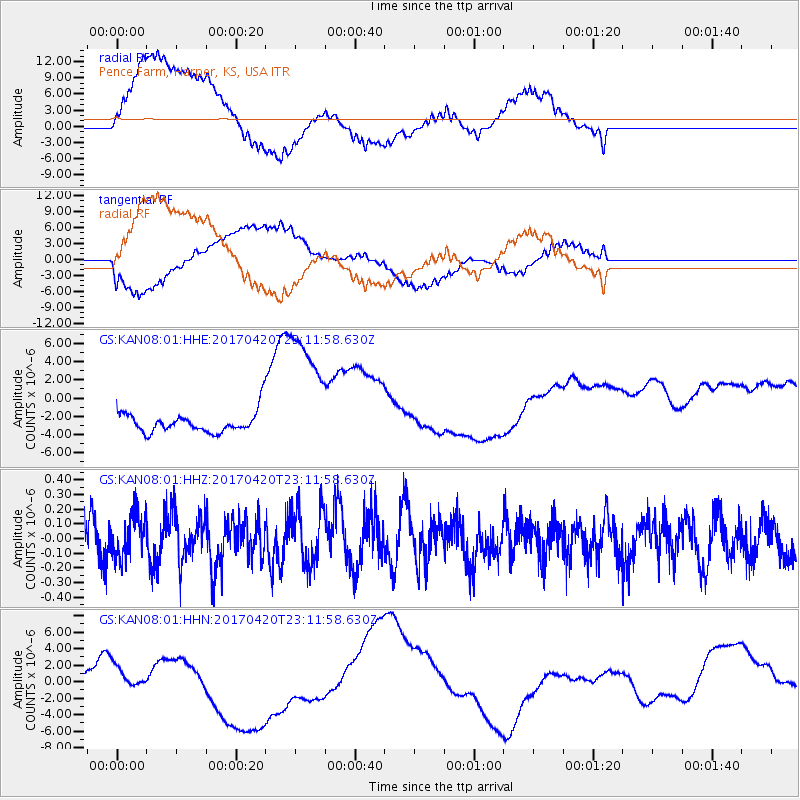
KAN08 Pence Farm, Harper, KS, USA - Earthquake Result Viewer
*The percent match for this event was below the threshold and hence no stack was calculated.
| Earthquake location: |
Tonga Islands |
| Earthquake latitude/longitude: |
-20.5/-173.6 |
| Earthquake time(UTC): |
2017/04/20 (110) 22:59:24 GMT |
| Earthquake Depth: |
13 km |
| Earthquake Magnitude: |
5.6 Mww |
| Earthquake Catalog/Contributor: |
NEIC PDE/us |
|
| Network: |
GS US Geological Survey Networks |
| Station: |
KAN08 Pence Farm, Harper, KS, USA |
| Lat/Lon: |
37.23 N/97.97 W |
| Elevation: |
375 m |
|
| Distance: |
91.4 deg |
| Az: |
50.666 deg |
| Baz: |
245.25 deg |
| Ray Param: |
$rayparam |
*The percent match for this event was below the threshold and hence was not used in the summary stack. |
|
| Radial Match: |
42.705883 % |
| Radial Bump: |
400 |
| Transverse Match: |
38.103306 % |
| Transverse Bump: |
400 |
| SOD ConfigId: |
2028011 |
| Insert Time: |
2017-05-04 23:00:30.713 +0000 |
| GWidth: |
2.5 |
| Max Bumps: |
400 |
| Tol: |
0.001 |
|
Signal To Noise
| Channel | StoN | STA | LTA |
| GS:KAN08:01:HHZ:20170420T23:11:58.630Z | 0.9309775 | 1.4349908E-7 | 1.5413808E-7 |
| GS:KAN08:01:HHN:20170420T23:11:58.630Z | 0.42840266 | 1.1108423E-6 | 2.5929864E-6 |
| GS:KAN08:01:HHE:20170420T23:11:58.630Z | 6.9593267 | 7.664397E-6 | 1.1013129E-6 |
| Arrivals |
| Ps | |
| PpPs | |
| PsPs/PpSs | |


