You are here: Home > Network List > G - GEOSCOPE Stations List
> Station MPG Montagne des Peres, French Guyana > Earthquake Result Viewer
MPG Montagne des Peres, French Guyana - Earthquake Result Viewer
| Earthquake location: |
Turkey |
| Earthquake latitude/longitude: |
38.4/39.1 |
| Earthquake time(UTC): |
2020/01/24 (024) 17:55:14 GMT |
| Earthquake Depth: |
10 km |
| Earthquake Magnitude: |
6.7 Mww |
| Earthquake Catalog/Contributor: |
NEIC PDE/us |
|
| Network: |
G GEOSCOPE |
| Station: |
MPG Montagne des Peres, French Guyana |
| Lat/Lon: |
5.11 N/52.64 W |
| Elevation: |
147 m |
|
| Distance: |
88.2 deg |
| Az: |
275.044 deg |
| Baz: |
51.781 deg |
| Ray Param: |
0.042766206 |
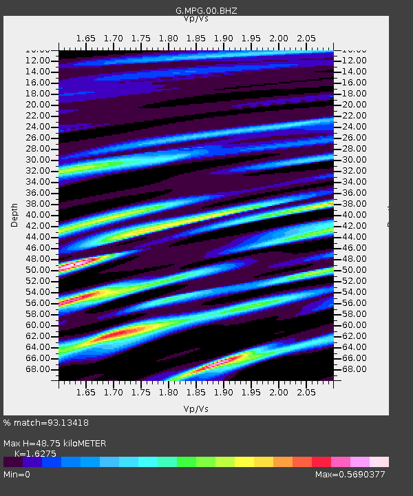
| Estimated Moho Depth: |
48.75 km |
| Estimated Crust Vp/Vs: |
1.63 |
| Assumed Crust Vp: |
6.472 km/s |
| Estimated Crust Vs: |
3.977 km/s |
| Estimated Crust Poisson's Ratio: |
0.20 |
|
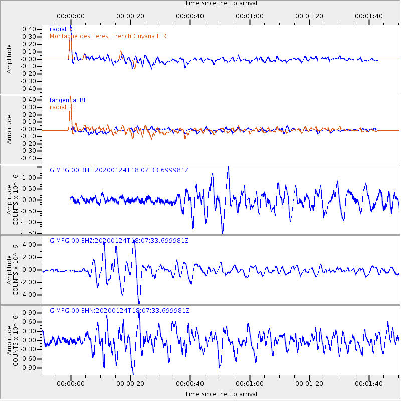
| Radial Match: |
93.13418 % |
| Radial Bump: |
400 |
| Transverse Match: |
80.50648 % |
| Transverse Bump: |
400 |
| SOD ConfigId: |
20465011 |
| Insert Time: |
2020-02-07 17:59:32.376 +0000 |
| GWidth: |
2.5 |
| Max Bumps: |
400 |
| Tol: |
0.001 |
|
Signal To Noise
| Channel | StoN | STA | LTA |
| G:MPG:00:BHZ:20200124T18:07:33.699981Z | 1.0094389 | 1.344788E-7 | 1.3322133E-7 |
| G:MPG:00:BHN:20200124T18:07:33.699981Z | 0.5572705 | 7.749451E-8 | 1.3906086E-7 |
| G:MPG:00:BHE:20200124T18:07:33.699981Z | 0.9499165 | 1.0082238E-7 | 1.0613816E-7 |
| Arrivals |
| Ps | 4.8 SECOND |
| PpPs | 19 SECOND |
| PsPs/PpSs | 24 SECOND |


