You are here: Home > Network List > US - United States National Seismic Network Stations List
> Station BOZ Bozeman, Montana, USA > Earthquake Result Viewer
BOZ Bozeman, Montana, USA - Earthquake Result Viewer
*The percent match for this event was below the threshold and hence no stack was calculated.
| Earthquake location: |
Tonga Islands |
| Earthquake latitude/longitude: |
-20.5/-173.6 |
| Earthquake time(UTC): |
2017/04/20 (110) 22:59:24 GMT |
| Earthquake Depth: |
13 km |
| Earthquake Magnitude: |
5.6 Mww |
| Earthquake Catalog/Contributor: |
NEIC PDE/us |
|
| Network: |
US United States National Seismic Network |
| Station: |
BOZ Bozeman, Montana, USA |
| Lat/Lon: |
45.65 N/111.63 W |
| Elevation: |
1589 m |
|
| Distance: |
86.5 deg |
| Az: |
38.341 deg |
| Baz: |
235.974 deg |
| Ray Param: |
$rayparam |
*The percent match for this event was below the threshold and hence was not used in the summary stack. |
|
| Radial Match: |
48.71227 % |
| Radial Bump: |
400 |
| Transverse Match: |
48.64723 % |
| Transverse Bump: |
400 |
| SOD ConfigId: |
2028011 |
| Insert Time: |
2017-05-04 23:02:55.215 +0000 |
| GWidth: |
2.5 |
| Max Bumps: |
400 |
| Tol: |
0.001 |
|
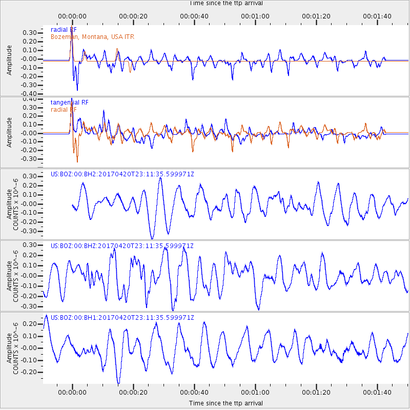
Signal To Noise
| Channel | StoN | STA | LTA |
| US:BOZ:00:BHZ:20170420T23:11:35.599971Z | 0.8227239 | 7.913264E-8 | 9.618372E-8 |
| US:BOZ:00:BH1:20170420T23:11:35.599971Z | 0.64324343 | 5.209593E-8 | 8.098945E-8 |
| US:BOZ:00:BH2:20170420T23:11:35.599971Z | 2.3040073 | 1.9494921E-7 | 8.4613106E-8 |
| Arrivals |
| Ps | |
| PpPs | |
| PsPs/PpSs | |


