You are here: Home > Network List > TS - TERRAscope (Southern California Seismic Network) Stations List
> Station PAS Pasadena, California, USA > Earthquake Result Viewer
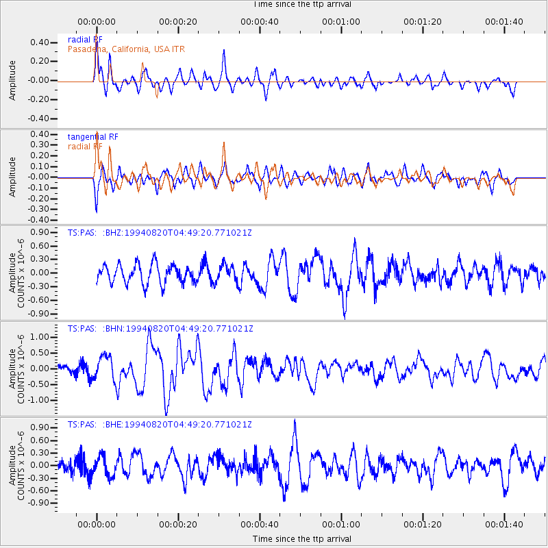
PAS Pasadena, California, USA - Earthquake Result Viewer
*The percent match for this event was below the threshold and hence no stack was calculated.
| Earthquake location: |
Kuril Islands |
| Earthquake latitude/longitude: |
44.7/149.1 |
| Earthquake time(UTC): |
1994/08/20 (232) 04:38:51 GMT |
| Earthquake Depth: |
33 km |
| Earthquake Magnitude: |
6.1 MB, 6.0 MS, 5.7 UNKNOWN, 6.3 MW |
| Earthquake Catalog/Contributor: |
WHDF/NEIC |
|
| Network: |
TS TERRAscope (Southern California Seismic Network) |
| Station: |
PAS Pasadena, California, USA |
| Lat/Lon: |
34.15 N/118.17 W |
| Elevation: |
295 m |
|
| Distance: |
68.7 deg |
| Az: |
62.791 deg |
| Baz: |
310.085 deg |
| Ray Param: |
$rayparam |
*The percent match for this event was below the threshold and hence was not used in the summary stack. |
|
| Radial Match: |
76.71872 % |
| Radial Bump: |
400 |
| Transverse Match: |
62.279926 % |
| Transverse Bump: |
400 |
| SOD ConfigId: |
4480 |
| Insert Time: |
2010-02-26 14:40:21.281 +0000 |
| GWidth: |
2.5 |
| Max Bumps: |
400 |
| Tol: |
0.001 |
|
Signal To Noise
| Channel | StoN | STA | LTA |
| TS:PAS: :BHN:19940820T04:49:20.771021Z | 2.7071872 | 3.8849507E-7 | 1.4350506E-7 |
| TS:PAS: :BHE:19940820T04:49:20.771021Z | 1.9653693 | 2.340715E-7 | 1.19097976E-7 |
| TS:PAS: :BHZ:19940820T04:49:20.771021Z | 0.92249143 | 1.900108E-7 | 2.0597567E-7 |
| Arrivals |
| Ps | |
| PpPs | |
| PsPs/PpSs | |


