You are here: Home > Network List > IU - Global Seismograph Network (GSN - IRIS/USGS) Stations List
> Station PMG Port Moresby, New Guinea > Earthquake Result Viewer
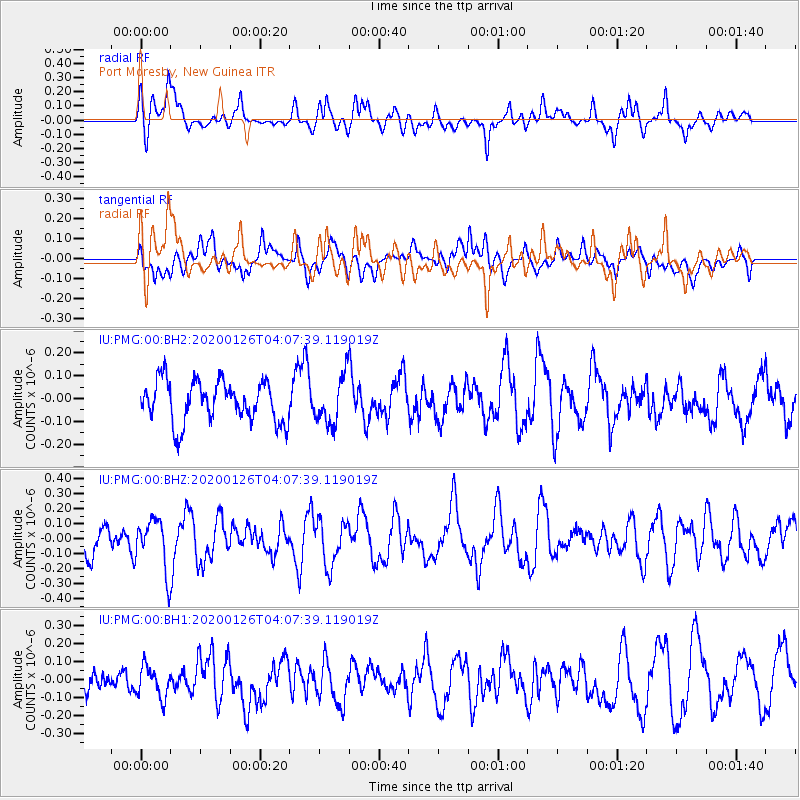
PMG Port Moresby, New Guinea - Earthquake Result Viewer
*The percent match for this event was below the threshold and hence no stack was calculated.
| Earthquake location: |
Andreanof Islands, Aleutian Is. |
| Earthquake latitude/longitude: |
51.0/-179.9 |
| Earthquake time(UTC): |
2020/01/26 (026) 03:57:19 GMT |
| Earthquake Depth: |
4.0 km |
| Earthquake Magnitude: |
5.7 Mi |
| Earthquake Catalog/Contributor: |
NEIC PDE/at |
|
| Network: |
IU Global Seismograph Network (GSN - IRIS/USGS) |
| Station: |
PMG Port Moresby, New Guinea |
| Lat/Lon: |
9.40 S/147.16 E |
| Elevation: |
90 m |
|
| Distance: |
66.6 deg |
| Az: |
215.767 deg |
| Baz: |
21.974 deg |
| Ray Param: |
$rayparam |
*The percent match for this event was below the threshold and hence was not used in the summary stack. |
|
| Radial Match: |
57.68771 % |
| Radial Bump: |
400 |
| Transverse Match: |
43.942356 % |
| Transverse Bump: |
400 |
| SOD ConfigId: |
20465011 |
| Insert Time: |
2020-02-09 04:04:05.675 +0000 |
| GWidth: |
2.5 |
| Max Bumps: |
400 |
| Tol: |
0.001 |
|
Signal To Noise
| Channel | StoN | STA | LTA |
| IU:PMG:00:BHZ:20200126T04:07:39.119019Z | 2.3707714 | 1.7097464E-7 | 7.211773E-8 |
| IU:PMG:00:BH1:20200126T04:07:39.119019Z | 1.1612407 | 8.466848E-8 | 7.291209E-8 |
| IU:PMG:00:BH2:20200126T04:07:39.119019Z | 1.1479409 | 1.02900756E-7 | 8.963942E-8 |
| Arrivals |
| Ps | |
| PpPs | |
| PsPs/PpSs | |


