You are here: Home > Network List > US - United States National Seismic Network Stations List
> Station MSO Missoula, Montana, USA > Earthquake Result Viewer
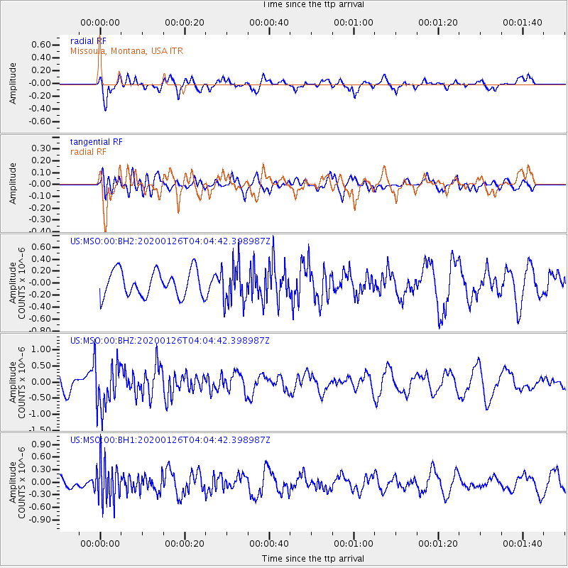
MSO Missoula, Montana, USA - Earthquake Result Viewer
*The percent match for this event was below the threshold and hence no stack was calculated.
| Earthquake location: |
Andreanof Islands, Aleutian Is. |
| Earthquake latitude/longitude: |
51.0/-179.9 |
| Earthquake time(UTC): |
2020/01/26 (026) 03:57:19 GMT |
| Earthquake Depth: |
4.0 km |
| Earthquake Magnitude: |
5.7 Mi |
| Earthquake Catalog/Contributor: |
NEIC PDE/at |
|
| Network: |
US United States National Seismic Network |
| Station: |
MSO Missoula, Montana, USA |
| Lat/Lon: |
46.83 N/113.94 W |
| Elevation: |
1264 m |
|
| Distance: |
42.3 deg |
| Az: |
68.858 deg |
| Baz: |
300.898 deg |
| Ray Param: |
$rayparam |
*The percent match for this event was below the threshold and hence was not used in the summary stack. |
|
| Radial Match: |
76.67886 % |
| Radial Bump: |
400 |
| Transverse Match: |
41.608315 % |
| Transverse Bump: |
400 |
| SOD ConfigId: |
20465011 |
| Insert Time: |
2020-02-09 04:13:05.151 +0000 |
| GWidth: |
2.5 |
| Max Bumps: |
400 |
| Tol: |
0.001 |
|
Signal To Noise
| Channel | StoN | STA | LTA |
| US:MSO:00:BHZ:20200126T04:04:42.398987Z | 2.275132 | 6.7332013E-7 | 2.9594773E-7 |
| US:MSO:00:BH1:20200126T04:04:42.398987Z | 3.517206 | 4.6895357E-7 | 1.3333128E-7 |
| US:MSO:00:BH2:20200126T04:04:42.398987Z | 1.5106455 | 3.2356309E-7 | 2.1418862E-7 |
| Arrivals |
| Ps | |
| PpPs | |
| PsPs/PpSs | |


