You are here: Home > Network List > TS - TERRAscope (Southern California Seismic Network) Stations List
> Station PFO Pinon Flat, California, USA > Earthquake Result Viewer
PFO Pinon Flat, California, USA - Earthquake Result Viewer
| Earthquake location: |
Central Bolivia |
| Earthquake latitude/longitude: |
-17.7/-65.4 |
| Earthquake time(UTC): |
1998/05/22 (142) 04:48:50 GMT |
| Earthquake Depth: |
24 km |
| Earthquake Magnitude: |
5.9 MB, 6.6 MS, 6.6 UNKNOWN, 6.2 ME |
| Earthquake Catalog/Contributor: |
WHDF/NEIC |
|
| Network: |
TS TERRAscope (Southern California Seismic Network) |
| Station: |
PFO Pinon Flat, California, USA |
| Lat/Lon: |
33.61 N/116.46 W |
| Elevation: |
1280 m |
|
| Distance: |
70.5 deg |
| Az: |
316.513 deg |
| Baz: |
128.192 deg |
| Ray Param: |
0.05490111 |
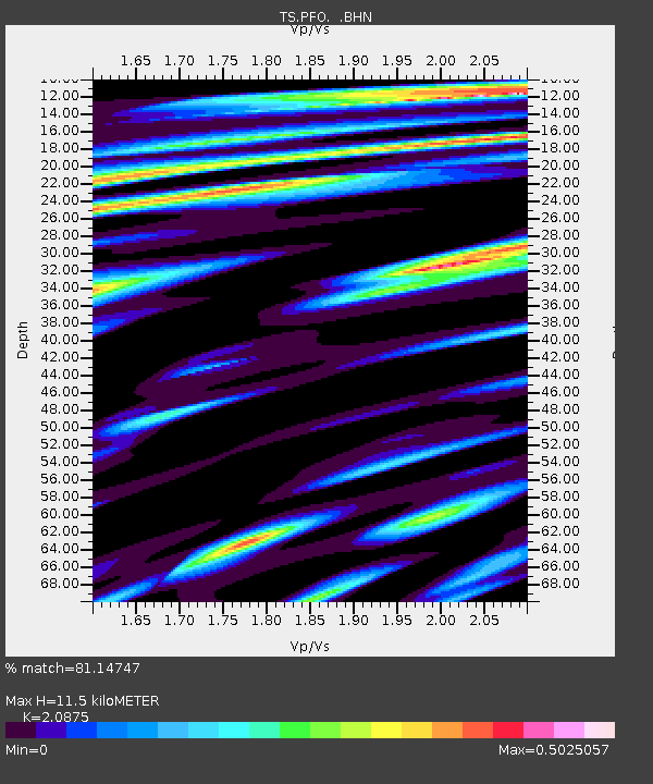
| Estimated Moho Depth: |
11.5 km |
| Estimated Crust Vp/Vs: |
2.09 |
| Assumed Crust Vp: |
6.264 km/s |
| Estimated Crust Vs: |
3.001 km/s |
| Estimated Crust Poisson's Ratio: |
0.35 |
|
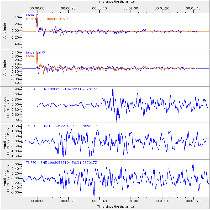
| Radial Match: |
81.14747 % |
| Radial Bump: |
317 |
| Transverse Match: |
69.66828 % |
| Transverse Bump: |
400 |
| SOD ConfigId: |
4480 |
| Insert Time: |
2010-02-26 14:40:28.859 +0000 |
| GWidth: |
2.5 |
| Max Bumps: |
400 |
| Tol: |
0.001 |
|
Signal To Noise
| Channel | StoN | STA | LTA |
| TS:PFO: :BHN:19980522T04:59:31.965002Z | 1.9473637 | 2.1798016E-7 | 1.1193603E-7 |
| TS:PFO: :BHE:19980522T04:59:31.967017Z | 0.8256953 | 7.181483E-8 | 8.697498E-8 |
| TS:PFO: :BHZ:19980522T04:59:31.967017Z | 1.5091176 | 9.415934E-8 | 6.239364E-8 |
| Arrivals |
| Ps | 2.1 SECOND |
| PpPs | 5.5 SECOND |
| PsPs/PpSs | 7.6 SECOND |


