You are here: Home > Network List > TS - TERRAscope (Southern California Seismic Network) Stations List
> Station PFO Pinon Flat, California, USA > Earthquake Result Viewer
PFO Pinon Flat, California, USA - Earthquake Result Viewer
| Earthquake location: |
Fiji Islands Region |
| Earthquake latitude/longitude: |
-20.4/-178.5 |
| Earthquake time(UTC): |
1996/10/19 (293) 14:53:48 GMT |
| Earthquake Depth: |
591 km |
| Earthquake Magnitude: |
6.1 MB, 6.9 UNKNOWN, 6.8 MW |
| Earthquake Catalog/Contributor: |
WHDF/NEIC |
|
| Network: |
TS TERRAscope (Southern California Seismic Network) |
| Station: |
PFO Pinon Flat, California, USA |
| Lat/Lon: |
33.61 N/116.46 W |
| Elevation: |
1280 m |
|
| Distance: |
79.9 deg |
| Az: |
48.495 deg |
| Baz: |
237.321 deg |
| Ray Param: |
0.046838466 |
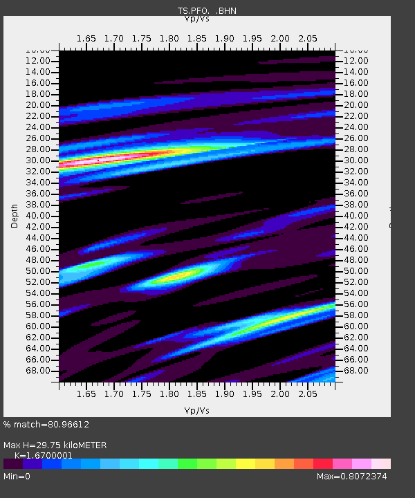
| Estimated Moho Depth: |
29.75 km |
| Estimated Crust Vp/Vs: |
1.67 |
| Assumed Crust Vp: |
6.264 km/s |
| Estimated Crust Vs: |
3.751 km/s |
| Estimated Crust Poisson's Ratio: |
0.22 |
|
| Radial Match: |
80.96612 % |
| Radial Bump: |
400 |
| Transverse Match: |
76.93338 % |
| Transverse Bump: |
400 |
| SOD ConfigId: |
4480 |
| Insert Time: |
2010-02-26 14:40:29.651 +0000 |
| GWidth: |
2.5 |
| Max Bumps: |
400 |
| Tol: |
0.001 |
|

Signal To Noise
| Channel | StoN | STA | LTA |
| TS:PFO: :BHN:19961019T15:04:25.749011Z | 10.733956 | 3.3905417E-6 | 3.1587064E-7 |
| TS:PFO: :BHE:19961019T15:04:25.749011Z | 2.6938493 | 3.554491E-7 | 1.319484E-7 |
| TS:PFO: :BHZ:19961019T15:04:25.749011Z | 3.5576172 | 9.731917E-7 | 2.7355156E-7 |
| Arrivals |
| Ps | 3.3 SECOND |
| PpPs | 12 SECOND |
| PsPs/PpSs | 16 SECOND |


