You are here: Home > Network List > TS - TERRAscope (Southern California Seismic Network) Stations List
> Station PFO Pinon Flat, California, USA > Earthquake Result Viewer
PFO Pinon Flat, California, USA - Earthquake Result Viewer
| Earthquake location: |
Near N. Coast Of Eastern Siberia |
| Earthquake latitude/longitude: |
67.0/-173.2 |
| Earthquake time(UTC): |
1996/10/24 (298) 19:31:53 GMT |
| Earthquake Depth: |
20 km |
| Earthquake Magnitude: |
6.0 MB, 5.9 MS, 6.1 UNKNOWN, 5.8 ME |
| Earthquake Catalog/Contributor: |
WHDF/NEIC |
|
| Network: |
TS TERRAscope (Southern California Seismic Network) |
| Station: |
PFO Pinon Flat, California, USA |
| Lat/Lon: |
33.61 N/116.46 W |
| Elevation: |
1280 m |
|
| Distance: |
46.7 deg |
| Az: |
106.277 deg |
| Baz: |
333.111 deg |
| Ray Param: |
0.07048347 |
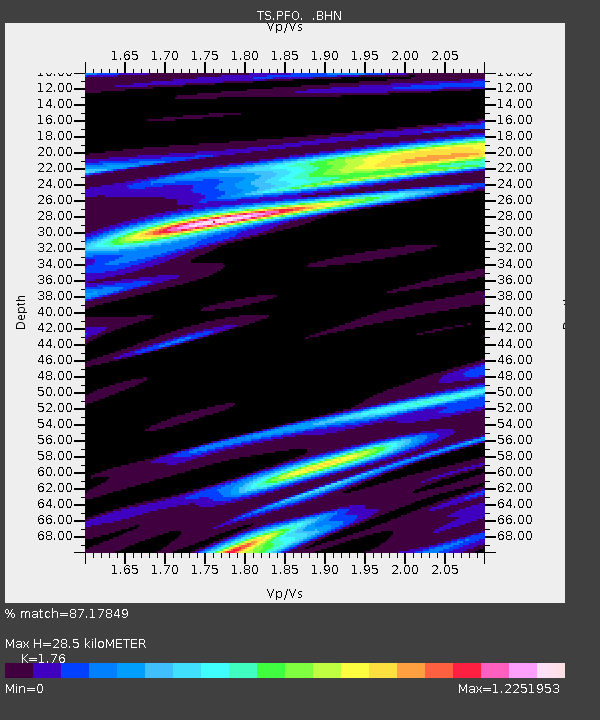
| Estimated Moho Depth: |
28.5 km |
| Estimated Crust Vp/Vs: |
1.76 |
| Assumed Crust Vp: |
6.264 km/s |
| Estimated Crust Vs: |
3.559 km/s |
| Estimated Crust Poisson's Ratio: |
0.26 |
|
| Radial Match: |
87.17849 % |
| Radial Bump: |
376 |
| Transverse Match: |
65.5994 % |
| Transverse Bump: |
400 |
| SOD ConfigId: |
4480 |
| Insert Time: |
2010-02-26 14:40:32.136 +0000 |
| GWidth: |
2.5 |
| Max Bumps: |
400 |
| Tol: |
0.001 |
|
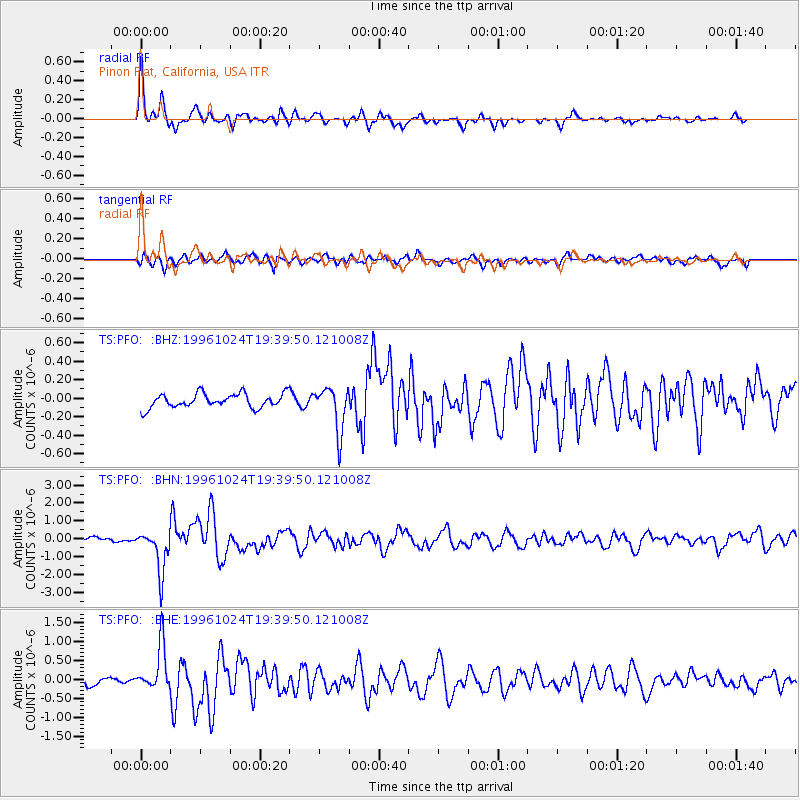
Signal To Noise
| Channel | StoN | STA | LTA |
| TS:PFO: :BHN:19961024T19:39:50.121008Z | 5.5555835 | 1.1911532E-6 | 2.144065E-7 |
| TS:PFO: :BHE:19961024T19:39:50.121008Z | 3.2357707 | 6.0448787E-7 | 1.8681418E-7 |
| TS:PFO: :BHZ:19961024T19:39:50.121008Z | 3.133562 | 2.3948505E-7 | 7.642582E-8 |
| Arrivals |
| Ps | 3.7 SECOND |
| PpPs | 12 SECOND |
| PsPs/PpSs | 16 SECOND |


