You are here: Home > Network List > TS - TERRAscope (Southern California Seismic Network) Stations List
> Station PFO Pinon Flat, California, USA > Earthquake Result Viewer
PFO Pinon Flat, California, USA - Earthquake Result Viewer
| Earthquake location: |
Santa Cruz Islands |
| Earthquake latitude/longitude: |
-11.0/166.2 |
| Earthquake time(UTC): |
1998/07/16 (197) 11:56:36 GMT |
| Earthquake Depth: |
110 km |
| Earthquake Magnitude: |
6.4 MB, 6.7 MS, 7.1 UNKNOWN, 6.9 ME |
| Earthquake Catalog/Contributor: |
WHDF/NEIC |
|
| Network: |
TS TERRAscope (Southern California Seismic Network) |
| Station: |
PFO Pinon Flat, California, USA |
| Lat/Lon: |
33.61 N/116.46 W |
| Elevation: |
1280 m |
|
| Distance: |
85.7 deg |
| Az: |
54.75 deg |
| Baz: |
253.879 deg |
| Ray Param: |
0.044307206 |
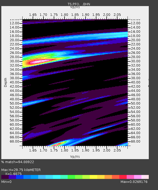
| Estimated Moho Depth: |
29.75 km |
| Estimated Crust Vp/Vs: |
1.69 |
| Assumed Crust Vp: |
6.264 km/s |
| Estimated Crust Vs: |
3.712 km/s |
| Estimated Crust Poisson's Ratio: |
0.23 |
|
| Radial Match: |
94.88922 % |
| Radial Bump: |
329 |
| Transverse Match: |
89.29935 % |
| Transverse Bump: |
400 |
| SOD ConfigId: |
4480 |
| Insert Time: |
2010-02-26 14:40:34.398 +0000 |
| GWidth: |
2.5 |
| Max Bumps: |
400 |
| Tol: |
0.001 |
|
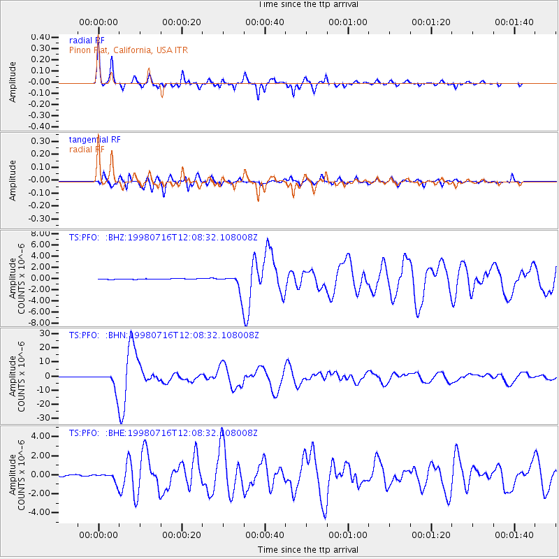
Signal To Noise
| Channel | StoN | STA | LTA |
| TS:PFO: :BHN:19980716T12:08:32.108008Z | 50.754906 | 7.3250167E-6 | 1.4432135E-7 |
| TS:PFO: :BHE:19980716T12:08:32.108008Z | 7.5131807 | 5.1626535E-7 | 6.871461E-8 |
| TS:PFO: :BHZ:19980716T12:08:32.108008Z | 33.684216 | 1.9031984E-6 | 5.650119E-8 |
| Arrivals |
| Ps | 3.3 SECOND |
| PpPs | 12 SECOND |
| PsPs/PpSs | 16 SECOND |


