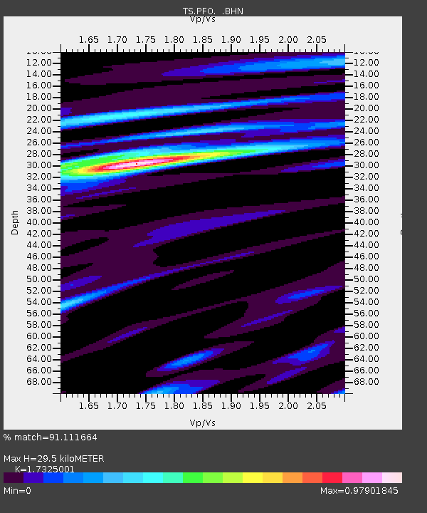
PFO Pinon Flat, California, USA - Earthquake Result Viewer

Earthquake location: Bonin Islands, Japan Region
Earthquake latitude/longitude: 28.0/143.5
Earthquake time(UTC): 1996/11/06 (311) 20:00:58 GMT
Earthquake Depth: 9.0 km
Earthquake Magnitude: 6.4 MB, 6.5 MS, 6.6 UNKNOWN, 6.4 ME
Earthquake Catalog/Contributor: WHDF/NEIC
Network: TS TERRAscope (Southern California Seismic Network)
Station: PFO Pinon Flat, California, USA
Lat/Lon: 33.61 N/116.46 W
Elevation: 1280 m
Distance: 82.6 deg
Az: 55.973 deg
Baz: 298.58 deg
Ray Param: 0.04678741
Estimated Moho Depth: 29.5 km
Estimated Crust Vp/Vs: 1.73
Assumed Crust Vp: 6.264 km/s
Estimated Crust Vs: 3.615 km/s
Estimated Crust Poisson's Ratio: 0.25
Radial Match: 91.111664 %
Radial Bump: 400
Transverse Match: 77.421165 %
Transverse Bump: 400
SOD ConfigId: 4480
Insert Time: 2010-02-26 14:40:36.171 +0000
GWidth: 2.5
Max Bumps: 400
Tol: 0.001

Signal To Noise

ChannelStoNSTALTA
TS:PFO: :BHN:19961106T20:12:50.688Z2.62064228.7001706E-73.319862E-7
TS:PFO: :BHE:19961106T20:12:50.688Z0.78387051.2152907E-71.5503717E-7
TS:PFO: :BHZ:19961106T20:12:50.688Z1.22558092.107775E-71.7198171E-7
Arrivals
Ps3.5 SECOND
PpPs13 SECOND
PsPs/PpSs16 SECOND