You are here: Home > Network List > TS - TERRAscope (Southern California Seismic Network) Stations List
> Station PFO Pinon Flat, California, USA > Earthquake Result Viewer
PFO Pinon Flat, California, USA - Earthquake Result Viewer
| Earthquake location: |
Bonin Islands, Japan Region |
| Earthquake latitude/longitude: |
29.0/138.9 |
| Earthquake time(UTC): |
1996/03/16 (076) 22:04:06 GMT |
| Earthquake Depth: |
477 km |
| Earthquake Magnitude: |
5.9 MB, 6.6 UNKNOWN, 6.1 MB |
| Earthquake Catalog/Contributor: |
WHDF/NEIC |
|
| Network: |
TS TERRAscope (Southern California Seismic Network) |
| Station: |
PFO Pinon Flat, California, USA |
| Lat/Lon: |
33.61 N/116.46 W |
| Elevation: |
1280 m |
|
| Distance: |
85.3 deg |
| Az: |
54.122 deg |
| Baz: |
301.717 deg |
| Ray Param: |
0.043524843 |
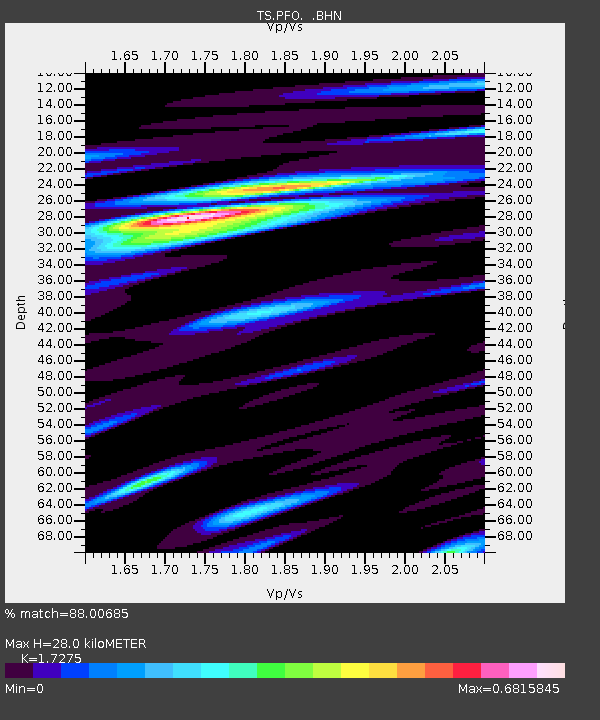
| Estimated Moho Depth: |
28.0 km |
| Estimated Crust Vp/Vs: |
1.73 |
| Assumed Crust Vp: |
6.264 km/s |
| Estimated Crust Vs: |
3.626 km/s |
| Estimated Crust Poisson's Ratio: |
0.25 |
|
| Radial Match: |
88.00685 % |
| Radial Bump: |
400 |
| Transverse Match: |
76.06955 % |
| Transverse Bump: |
400 |
| SOD ConfigId: |
4480 |
| Insert Time: |
2010-02-26 14:40:37.462 +0000 |
| GWidth: |
2.5 |
| Max Bumps: |
400 |
| Tol: |
0.001 |
|
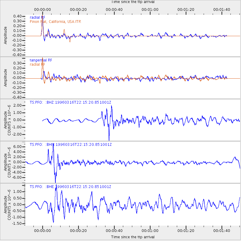
Signal To Noise
| Channel | StoN | STA | LTA |
| TS:PFO: :BHN:19960316T22:15:20.851001Z | 6.0576043 | 1.4499733E-6 | 2.3936414E-7 |
| TS:PFO: :BHE:19960316T22:15:20.851001Z | 2.3908122 | 2.779824E-7 | 1.1627112E-7 |
| TS:PFO: :BHZ:19960316T22:15:20.851001Z | 2.6303647 | 4.4826913E-7 | 1.704209E-7 |
| Arrivals |
| Ps | 3.3 SECOND |
| PpPs | 12 SECOND |
| PsPs/PpSs | 15 SECOND |


