You are here: Home > Network List > MN - MEDNET Project Stations List
> Station TUE Stuetta, Italy > Earthquake Result Viewer
TUE Stuetta, Italy - Earthquake Result Viewer
| Earthquake location: |
Hokkaido, Japan Region |
| Earthquake latitude/longitude: |
42.9/145.2 |
| Earthquake time(UTC): |
2004/12/06 (341) 14:15:11 GMT |
| Earthquake Depth: |
35 km |
| Earthquake Magnitude: |
6.5 MB, 6.5 MS, 6.8 MW, 6.8 MW |
| Earthquake Catalog/Contributor: |
WHDF/NEIC |
|
| Network: |
MN MEDNET Project |
| Station: |
TUE Stuetta, Italy |
| Lat/Lon: |
46.47 N/9.35 E |
| Elevation: |
1924 m |
|
| Distance: |
82.8 deg |
| Az: |
330.989 deg |
| Baz: |
31.04 deg |
| Ray Param: |
0.046599295 |
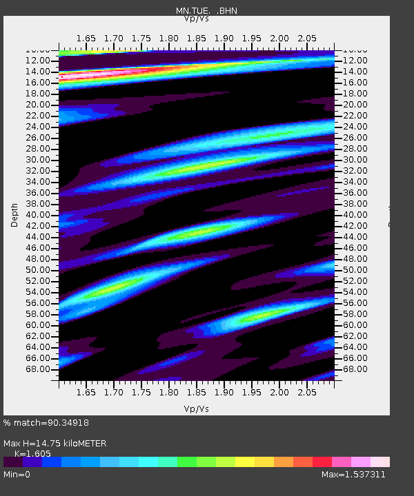
| Estimated Moho Depth: |
14.75 km |
| Estimated Crust Vp/Vs: |
1.61 |
| Assumed Crust Vp: |
6.416 km/s |
| Estimated Crust Vs: |
3.997 km/s |
| Estimated Crust Poisson's Ratio: |
0.18 |
|
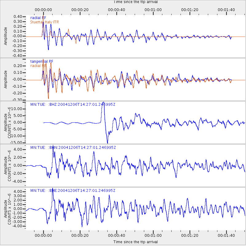
| Radial Match: |
90.34918 % |
| Radial Bump: |
400 |
| Transverse Match: |
89.01111 % |
| Transverse Bump: |
400 |
| SOD ConfigId: |
2459 |
| Insert Time: |
2010-03-08 17:33:41.963 +0000 |
| GWidth: |
2.5 |
| Max Bumps: |
400 |
| Tol: |
0.001 |
|
Signal To Noise
| Channel | StoN | STA | LTA |
| MN:TUE: :BHN:20041206T14:27:01.246995Z | 7.6322374 | 1.4384153E-6 | 1.8846575E-7 |
| MN:TUE: :BHE:20041206T14:27:01.246995Z | 6.587132 | 1.5386275E-6 | 2.3358079E-7 |
| MN:TUE: :BHZ:20041206T14:27:01.246995Z | 19.638872 | 8.1885055E-6 | 4.1695395E-7 |
| Arrivals |
| Ps | 1.4 SECOND |
| PpPs | 5.8 SECOND |
| PsPs/PpSs | 7.3 SECOND |


