You are here: Home > Network List > TS - TERRAscope (Southern California Seismic Network) Stations List
> Station PFO Pinon Flat, California, USA > Earthquake Result Viewer
PFO Pinon Flat, California, USA - Earthquake Result Viewer
| Earthquake location: |
Vanuatu Islands |
| Earthquake latitude/longitude: |
-14.7/167.3 |
| Earthquake time(UTC): |
1996/03/17 (077) 14:48:56 GMT |
| Earthquake Depth: |
164 km |
| Earthquake Magnitude: |
5.8 MB, 6.0 MS, 6.7 UNKNOWN, 6.1 MS |
| Earthquake Catalog/Contributor: |
WHDF/NEIC |
|
| Network: |
TS TERRAscope (Southern California Seismic Network) |
| Station: |
PFO Pinon Flat, California, USA |
| Lat/Lon: |
33.61 N/116.46 W |
| Elevation: |
1280 m |
|
| Distance: |
87.0 deg |
| Az: |
54.268 deg |
| Baz: |
250.262 deg |
| Ray Param: |
0.04330106 |
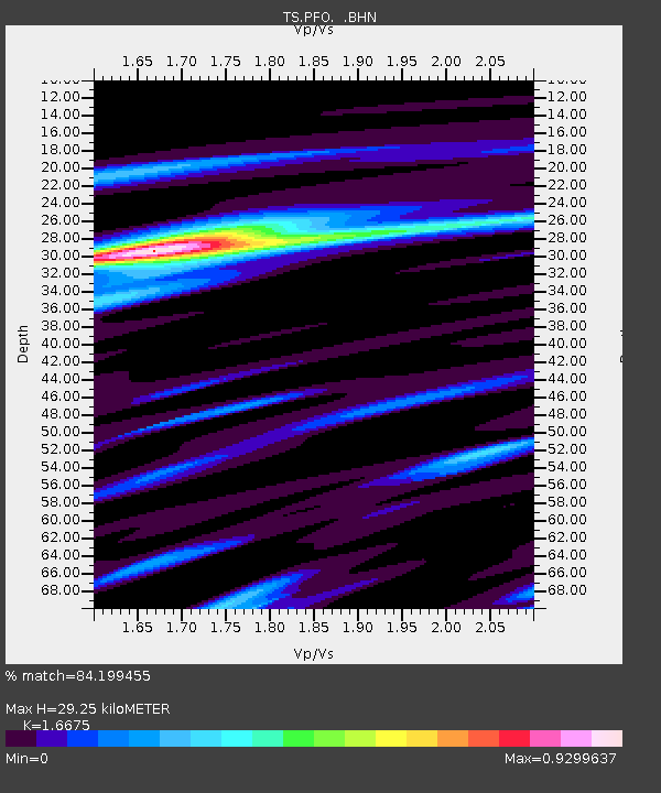
| Estimated Moho Depth: |
29.25 km |
| Estimated Crust Vp/Vs: |
1.67 |
| Assumed Crust Vp: |
6.264 km/s |
| Estimated Crust Vs: |
3.756 km/s |
| Estimated Crust Poisson's Ratio: |
0.22 |
|
| Radial Match: |
84.199455 % |
| Radial Bump: |
370 |
| Transverse Match: |
79.81346 % |
| Transverse Bump: |
369 |
| SOD ConfigId: |
4480 |
| Insert Time: |
2010-02-26 14:40:38.266 +0000 |
| GWidth: |
2.5 |
| Max Bumps: |
400 |
| Tol: |
0.001 |
|
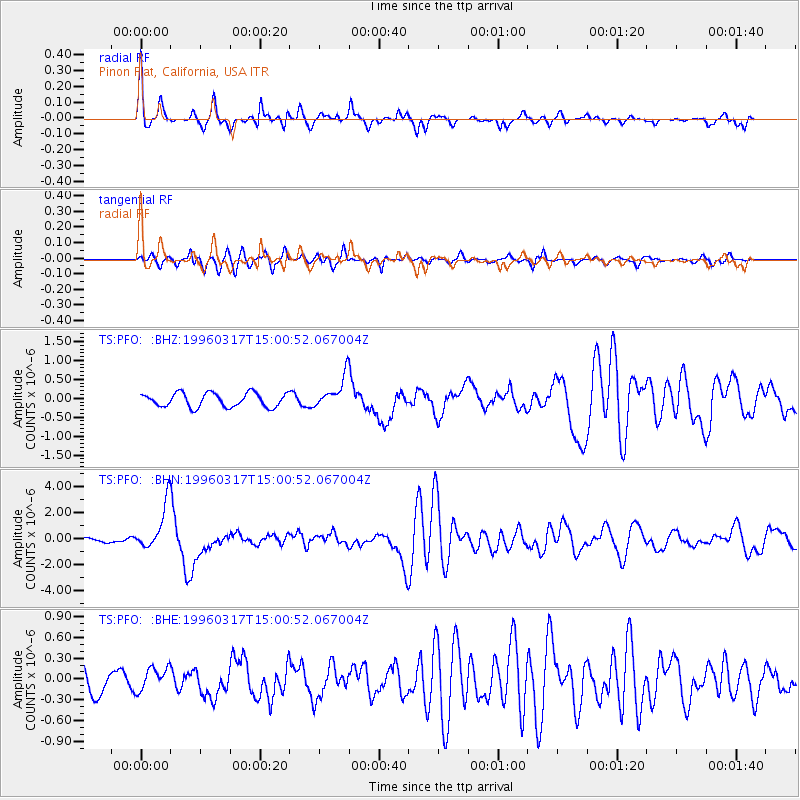
Signal To Noise
| Channel | StoN | STA | LTA |
| TS:PFO: :BHN:19960317T15:00:52.067004Z | 6.8489485 | 1.8045652E-6 | 2.6348062E-7 |
| TS:PFO: :BHE:19960317T15:00:52.067004Z | 1.081588 | 1.6862744E-7 | 1.5590726E-7 |
| TS:PFO: :BHZ:19960317T15:00:52.067004Z | 2.2577581 | 4.1276343E-7 | 1.8282003E-7 |
| Arrivals |
| Ps | 3.2 SECOND |
| PpPs | 12 SECOND |
| PsPs/PpSs | 15 SECOND |


