You are here: Home > Network List > MN - MEDNET Project Stations List
> Station TUE Stuetta, Italy > Earthquake Result Viewer
TUE Stuetta, Italy - Earthquake Result Viewer
| Earthquake location: |
Sea Of Okhotsk |
| Earthquake latitude/longitude: |
53.9/152.9 |
| Earthquake time(UTC): |
2008/07/05 (187) 02:12:04 GMT |
| Earthquake Depth: |
633 km |
| Earthquake Magnitude: |
6.8 MB, 7.7 MW, 7.7 MW |
| Earthquake Catalog/Contributor: |
WHDF/NEIC |
|
| Network: |
MN MEDNET Project |
| Station: |
TUE Stuetta, Italy |
| Lat/Lon: |
46.47 N/9.35 E |
| Elevation: |
1924 m |
|
| Distance: |
75.3 deg |
| Az: |
334.876 deg |
| Baz: |
21.328 deg |
| Ray Param: |
0.04964498 |
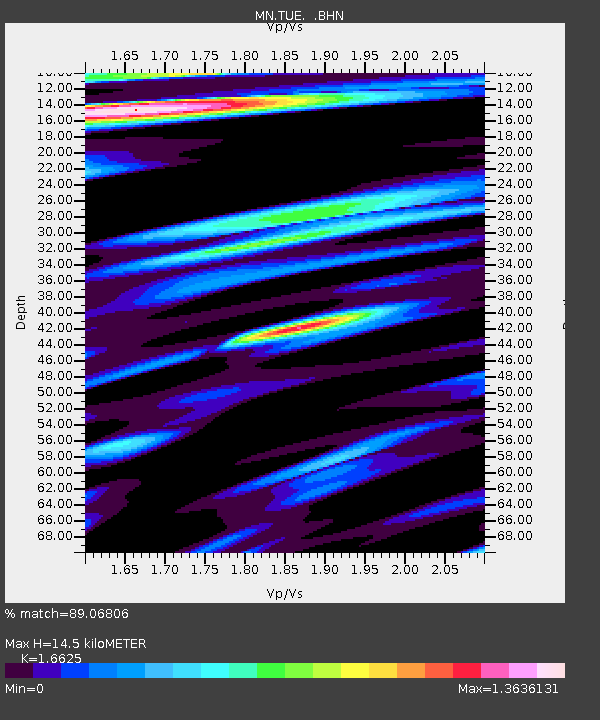
| Estimated Moho Depth: |
14.5 km |
| Estimated Crust Vp/Vs: |
1.66 |
| Assumed Crust Vp: |
6.416 km/s |
| Estimated Crust Vs: |
3.859 km/s |
| Estimated Crust Poisson's Ratio: |
0.22 |
|
| Radial Match: |
89.06806 % |
| Radial Bump: |
400 |
| Transverse Match: |
89.20999 % |
| Transverse Bump: |
400 |
| SOD ConfigId: |
2504 |
| Insert Time: |
2010-03-08 17:34:04.583 +0000 |
| GWidth: |
2.5 |
| Max Bumps: |
400 |
| Tol: |
0.001 |
|
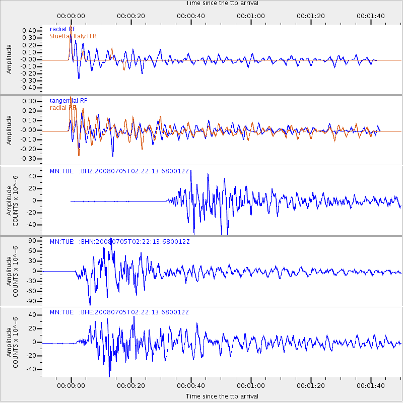
Signal To Noise
| Channel | StoN | STA | LTA |
| MN:TUE: :BHN:20080705T02:22:13.680012Z | 16.522722 | 8.543316E-6 | 5.170646E-7 |
| MN:TUE: :BHE:20080705T02:22:13.680012Z | 8.749512 | 2.295898E-6 | 2.62403E-7 |
| MN:TUE: :BHZ:20080705T02:22:13.680012Z | 13.925556 | 2.3109276E-6 | 1.6594869E-7 |
| Arrivals |
| Ps | 1.5 SECOND |
| PpPs | 5.8 SECOND |
| PsPs/PpSs | 7.4 SECOND |


