You are here: Home > Network List > MN - MEDNET Project Stations List
> Station TUE Stuetta, Italy > Earthquake Result Viewer
TUE Stuetta, Italy - Earthquake Result Viewer
| Earthquake location: |
Kuril Islands |
| Earthquake latitude/longitude: |
46.4/153.2 |
| Earthquake time(UTC): |
2008/03/03 (063) 09:31:02 GMT |
| Earthquake Depth: |
10 km |
| Earthquake Magnitude: |
6.2 MB, 6.5 MS, 6.5 MW, 6.5 MW |
| Earthquake Catalog/Contributor: |
WHDF/NEIC |
|
| Network: |
MN MEDNET Project |
| Station: |
TUE Stuetta, Italy |
| Lat/Lon: |
46.47 N/9.35 E |
| Elevation: |
1924 m |
|
| Distance: |
82.2 deg |
| Az: |
335.687 deg |
| Baz: |
24.345 deg |
| Ray Param: |
0.047051404 |
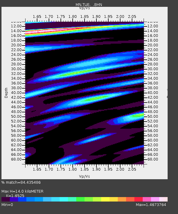
| Estimated Moho Depth: |
14.0 km |
| Estimated Crust Vp/Vs: |
1.65 |
| Assumed Crust Vp: |
6.416 km/s |
| Estimated Crust Vs: |
3.882 km/s |
| Estimated Crust Poisson's Ratio: |
0.21 |
|
| Radial Match: |
84.435486 % |
| Radial Bump: |
400 |
| Transverse Match: |
68.1212 % |
| Transverse Bump: |
400 |
| SOD ConfigId: |
2564 |
| Insert Time: |
2010-03-08 17:34:14.826 +0000 |
| GWidth: |
2.5 |
| Max Bumps: |
400 |
| Tol: |
0.001 |
|
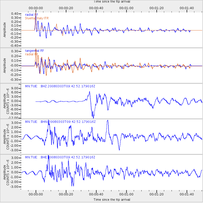
Signal To Noise
| Channel | StoN | STA | LTA |
| MN:TUE: :BHN:20080303T09:42:52.179016Z | 1.1385844 | 3.5869587E-7 | 3.1503671E-7 |
| MN:TUE: :BHE:20080303T09:42:52.179016Z | 1.0790875 | 4.693791E-7 | 4.3497784E-7 |
| MN:TUE: :BHZ:20080303T09:42:52.179016Z | 4.8876266 | 1.5726009E-6 | 3.2175146E-7 |
| Arrivals |
| Ps | 1.5 SECOND |
| PpPs | 5.6 SECOND |
| PsPs/PpSs | 7.1 SECOND |


