You are here: Home > Network List > TX - Texas Seismological Network Stations List
> Station PLPT Palo Pinto > Earthquake Result Viewer
PLPT Palo Pinto - Earthquake Result Viewer
| Earthquake location: |
Andreanof Islands, Aleutian Is. |
| Earthquake latitude/longitude: |
50.9/-179.9 |
| Earthquake time(UTC): |
2020/01/26 (026) 06:31:55 GMT |
| Earthquake Depth: |
1.0 km |
| Earthquake Magnitude: |
5.6 Mi |
| Earthquake Catalog/Contributor: |
NEIC PDE/at |
|
| Network: |
TX Texas Seismological Network |
| Station: |
PLPT Palo Pinto |
| Lat/Lon: |
32.81 N/98.32 W |
| Elevation: |
336 m |
|
| Distance: |
60.3 deg |
| Az: |
73.57 deg |
| Baz: |
313.872 deg |
| Ray Param: |
0.061662666 |
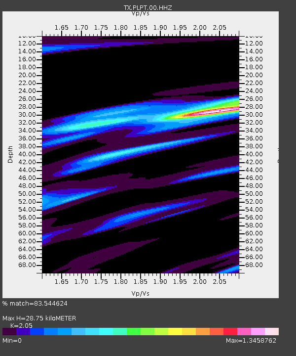
| Estimated Moho Depth: |
28.75 km |
| Estimated Crust Vp/Vs: |
2.05 |
| Assumed Crust Vp: |
6.426 km/s |
| Estimated Crust Vs: |
3.135 km/s |
| Estimated Crust Poisson's Ratio: |
0.34 |
|
| Radial Match: |
83.544624 % |
| Radial Bump: |
400 |
| Transverse Match: |
64.09246 % |
| Transverse Bump: |
392 |
| SOD ConfigId: |
20465011 |
| Insert Time: |
2020-02-09 06:54:32.141 +0000 |
| GWidth: |
2.5 |
| Max Bumps: |
400 |
| Tol: |
0.001 |
|

Signal To Noise
| Channel | StoN | STA | LTA |
| TX:PLPT:00:HHZ:20200126T06:41:33.89502Z | 4.9535522 | 7.8461613E-7 | 1.5839464E-7 |
| TX:PLPT:00:HH1:20200126T06:41:33.89502Z | 2.1868677 | 3.276513E-7 | 1.4982676E-7 |
| TX:PLPT:00:HH2:20200126T06:41:33.89502Z | 2.7446165 | 4.0096774E-7 | 1.4609245E-7 |
| Arrivals |
| Ps | 4.9 SECOND |
| PpPs | 13 SECOND |
| PsPs/PpSs | 18 SECOND |


