You are here: Home > Network List > TS - TERRAscope (Southern California Seismic Network) Stations List
> Station PFO Pinon Flat, California, USA > Earthquake Result Viewer
PFO Pinon Flat, California, USA - Earthquake Result Viewer
| Earthquake location: |
Tonga Islands |
| Earthquake latitude/longitude: |
-19.9/-173.3 |
| Earthquake time(UTC): |
1997/02/07 (038) 08:41:13 GMT |
| Earthquake Depth: |
28 km |
| Earthquake Magnitude: |
6.0 MB, 6.2 MS, 6.4 UNKNOWN, 6.0 ME |
| Earthquake Catalog/Contributor: |
WHDF/NEIC |
|
| Network: |
TS TERRAscope (Southern California Seismic Network) |
| Station: |
PFO Pinon Flat, California, USA |
| Lat/Lon: |
33.61 N/116.46 W |
| Elevation: |
1280 m |
|
| Distance: |
75.9 deg |
| Az: |
46.079 deg |
| Baz: |
234.331 deg |
| Ray Param: |
0.05132317 |
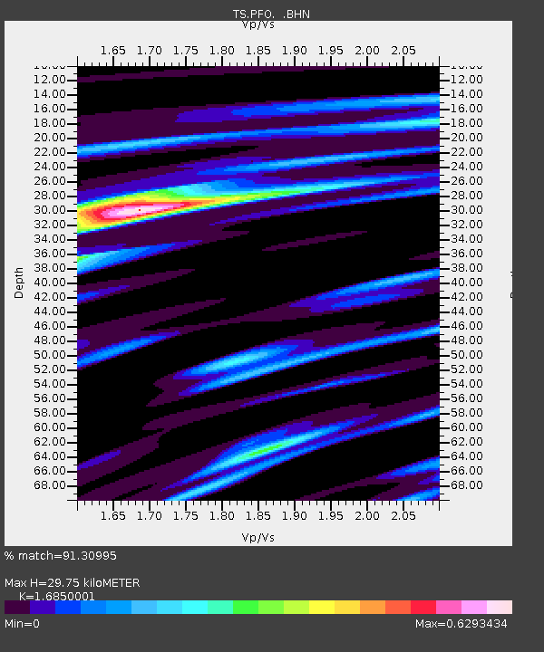
| Estimated Moho Depth: |
29.75 km |
| Estimated Crust Vp/Vs: |
1.69 |
| Assumed Crust Vp: |
6.264 km/s |
| Estimated Crust Vs: |
3.717 km/s |
| Estimated Crust Poisson's Ratio: |
0.23 |
|
| Radial Match: |
91.30995 % |
| Radial Bump: |
400 |
| Transverse Match: |
70.29588 % |
| Transverse Bump: |
400 |
| SOD ConfigId: |
4480 |
| Insert Time: |
2010-02-26 14:40:42.881 +0000 |
| GWidth: |
2.5 |
| Max Bumps: |
400 |
| Tol: |
0.001 |
|

Signal To Noise
| Channel | StoN | STA | LTA |
| TS:PFO: :BHN:19970207T08:52:26.157019Z | 7.5771427 | 2.1516976E-6 | 2.8397216E-7 |
| TS:PFO: :BHE:19970207T08:52:26.157996Z | 1.8709543 | 3.4501477E-7 | 1.8440578E-7 |
| TS:PFO: :BHZ:19970207T08:52:26.157019Z | 2.2135477 | 4.1780024E-7 | 1.887469E-7 |
| Arrivals |
| Ps | 3.4 SECOND |
| PpPs | 12 SECOND |
| PsPs/PpSs | 16 SECOND |


