You are here: Home > Network List > US - United States National Seismic Network Stations List
> Station MNTX Cornudas Mountains, Texas, USA > Earthquake Result Viewer
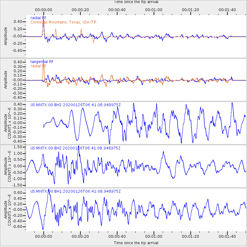
MNTX Cornudas Mountains, Texas, USA - Earthquake Result Viewer
*The percent match for this event was below the threshold and hence no stack was calculated.
| Earthquake location: |
Andreanof Islands, Aleutian Is. |
| Earthquake latitude/longitude: |
50.9/-179.9 |
| Earthquake time(UTC): |
2020/01/26 (026) 06:31:55 GMT |
| Earthquake Depth: |
1.0 km |
| Earthquake Magnitude: |
5.6 Mi |
| Earthquake Catalog/Contributor: |
NEIC PDE/at |
|
| Network: |
US United States National Seismic Network |
| Station: |
MNTX Cornudas Mountains, Texas, USA |
| Lat/Lon: |
31.70 N/105.38 W |
| Elevation: |
404 m |
|
| Distance: |
56.7 deg |
| Az: |
79.347 deg |
| Baz: |
313.139 deg |
| Ray Param: |
$rayparam |
*The percent match for this event was below the threshold and hence was not used in the summary stack. |
|
| Radial Match: |
69.83707 % |
| Radial Bump: |
394 |
| Transverse Match: |
50.53384 % |
| Transverse Bump: |
347 |
| SOD ConfigId: |
20465011 |
| Insert Time: |
2020-02-09 06:56:01.261 +0000 |
| GWidth: |
2.5 |
| Max Bumps: |
400 |
| Tol: |
0.001 |
|
Signal To Noise
| Channel | StoN | STA | LTA |
| US:MNTX:00:BHZ:20200126T06:41:08.948975Z | 2.1800194 | 4.876629E-7 | 2.2369656E-7 |
| US:MNTX:00:BH1:20200126T06:41:08.948975Z | 3.6934235 | 4.591965E-7 | 1.2432815E-7 |
| US:MNTX:00:BH2:20200126T06:41:08.948975Z | 0.88293684 | 1.3479527E-7 | 1.5266694E-7 |
| Arrivals |
| Ps | |
| PpPs | |
| PsPs/PpSs | |


