You are here: Home > Network List > MN - MEDNET Project Stations List
> Station TUE Stuetta, Italy > Earthquake Result Viewer
TUE Stuetta, Italy - Earthquake Result Viewer
| Earthquake location: |
Sea Of Okhotsk |
| Earthquake latitude/longitude: |
54.2/154.3 |
| Earthquake time(UTC): |
2008/11/24 (329) 09:02:58 GMT |
| Earthquake Depth: |
492 km |
| Earthquake Magnitude: |
6.5 MB, 7.3 MW, 7.3 MW |
| Earthquake Catalog/Contributor: |
WHDF/NEIC |
|
| Network: |
MN MEDNET Project |
| Station: |
TUE Stuetta, Italy |
| Lat/Lon: |
46.47 N/9.35 E |
| Elevation: |
1924 m |
|
| Distance: |
75.4 deg |
| Az: |
335.799 deg |
| Baz: |
20.393 deg |
| Ray Param: |
0.05018497 |
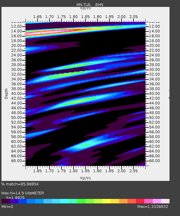
| Estimated Moho Depth: |
14.5 km |
| Estimated Crust Vp/Vs: |
1.66 |
| Assumed Crust Vp: |
6.416 km/s |
| Estimated Crust Vs: |
3.859 km/s |
| Estimated Crust Poisson's Ratio: |
0.22 |
|
| Radial Match: |
85.96954 % |
| Radial Bump: |
400 |
| Transverse Match: |
75.22241 % |
| Transverse Bump: |
400 |
| SOD ConfigId: |
2658 |
| Insert Time: |
2010-03-08 17:35:22.580 +0000 |
| GWidth: |
2.5 |
| Max Bumps: |
400 |
| Tol: |
0.001 |
|
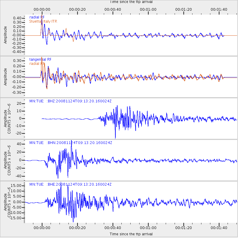
Signal To Noise
| Channel | StoN | STA | LTA |
| MN:TUE: :BHN:20081124T09:13:20.160024Z | 18.287874 | 6.9819057E-6 | 3.8177788E-7 |
| MN:TUE: :BHE:20081124T09:13:20.160024Z | 5.4899683 | 1.6968478E-6 | 3.090815E-7 |
| MN:TUE: :BHZ:20081124T09:13:20.160024Z | 5.131688 | 1.417494E-6 | 2.7622372E-7 |
| Arrivals |
| Ps | 1.5 SECOND |
| PpPs | 5.8 SECOND |
| PsPs/PpSs | 7.4 SECOND |


