You are here: Home > Network List > UW - Pacific Northwest Regional Seismic Network Stations List
> Station IRON Crane, OR, USA > Earthquake Result Viewer
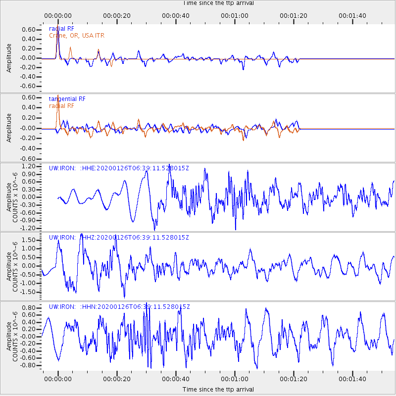
IRON Crane, OR, USA - Earthquake Result Viewer
*The percent match for this event was below the threshold and hence no stack was calculated.
| Earthquake location: |
Andreanof Islands, Aleutian Is. |
| Earthquake latitude/longitude: |
50.9/-179.9 |
| Earthquake time(UTC): |
2020/01/26 (026) 06:31:55 GMT |
| Earthquake Depth: |
1.0 km |
| Earthquake Magnitude: |
5.6 Mi |
| Earthquake Catalog/Contributor: |
NEIC PDE/at |
|
| Network: |
UW Pacific Northwest Regional Seismic Network |
| Station: |
IRON Crane, OR, USA |
| Lat/Lon: |
43.36 N/118.47 W |
| Elevation: |
1226 m |
|
| Distance: |
41.4 deg |
| Az: |
75.748 deg |
| Baz: |
302.752 deg |
| Ray Param: |
$rayparam |
*The percent match for this event was below the threshold and hence was not used in the summary stack. |
|
| Radial Match: |
61.519966 % |
| Radial Bump: |
294 |
| Transverse Match: |
38.640724 % |
| Transverse Bump: |
400 |
| SOD ConfigId: |
20465011 |
| Insert Time: |
2020-02-09 06:57:36.880 +0000 |
| GWidth: |
2.5 |
| Max Bumps: |
400 |
| Tol: |
0.001 |
|
Signal To Noise
| Channel | StoN | STA | LTA |
| UW:IRON: :HHZ:20200126T06:39:11.528015Z | 2.8168511 | 9.2652556E-7 | 3.2892245E-7 |
| UW:IRON: :HHN:20200126T06:39:11.528015Z | 1.7271774 | 3.7840923E-7 | 2.1909113E-7 |
| UW:IRON: :HHE:20200126T06:39:11.528015Z | 3.0046804 | 7.7703265E-7 | 2.5860743E-7 |
| Arrivals |
| Ps | |
| PpPs | |
| PsPs/PpSs | |


