You are here: Home > Network List > TS - TERRAscope (Southern California Seismic Network) Stations List
> Station PFO Pinon Flat, California, USA > Earthquake Result Viewer
PFO Pinon Flat, California, USA - Earthquake Result Viewer

| Earthquake location: |
Northern Mid-Atlantic Ridge |
| Earthquake latitude/longitude: |
10.8/-42.6 |
| Earthquake time(UTC): |
1995/02/02 (033) 12:53:53 GMT |
| Earthquake Depth: |
10 km |
| Earthquake Magnitude: |
5.6 MB, 5.4 MS, 5.8 UNKNOWN |
| Earthquake Catalog/Contributor: |
WHDF/NEIC |
|
| Network: |
TS TERRAscope (Southern California Seismic Network) |
| Station: |
PFO Pinon Flat, California, USA |
| Lat/Lon: |
33.61 N/116.46 W |
| Elevation: |
1280 m |
|
| Distance: |
70.8 deg |
| Az: |
301.869 deg |
| Baz: |
89.722 deg |
| Ray Param: |
0.054772012 |
| Estimated Moho Depth: |
10.0 km |
| Estimated Crust Vp/Vs: |
1.60 |
| Assumed Crust Vp: |
6.264 km/s |
| Estimated Crust Vs: |
3.915 km/s |
| Estimated Crust Poisson's Ratio: |
0.18 |
|
| Radial Match: |
99.98658 % |
| Radial Bump: |
2 |
| Transverse Match: |
99.98878 % |
| Transverse Bump: |
3 |
| SOD ConfigId: |
4480 |
| Insert Time: |
2010-02-26 14:40:44.406 +0000 |
| GWidth: |
2.5 |
| Max Bumps: |
400 |
| Tol: |
0.001 |
|
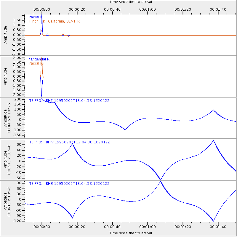
Signal To Noise
| Channel | StoN | STA | LTA |
| TS:PFO: :BHN:19950202T13:04:38.162012Z | 1.0594846 | 5.9326103E-5 | 5.5995246E-5 |
| TS:PFO: :BHE:19950202T13:04:38.162012Z | 1.056515 | 9.297763E-5 | 8.800408E-5 |
| TS:PFO: :BHZ:19950202T13:04:38.162012Z | 1.0559598 | 8.872812E-5 | 8.402603E-5 |
| Arrivals |
| Ps | 1.0 SECOND |
| PpPs | 4.0 SECOND |
| PsPs/PpSs | 5.0 SECOND |


