You are here: Home > Network List > TS - TERRAscope (Southern California Seismic Network) Stations List
> Station PFO Pinon Flat, California, USA > Earthquake Result Viewer
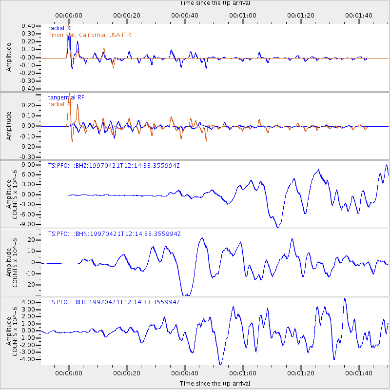
PFO Pinon Flat, California, USA - Earthquake Result Viewer

| Earthquake location: |
Santa Cruz Islands |
| Earthquake latitude/longitude: |
-12.6/166.7 |
| Earthquake time(UTC): |
1997/04/21 (111) 12:02:26 GMT |
| Earthquake Depth: |
33 km |
| Earthquake Magnitude: |
6.4 MB, 7.9 MS, 7.9 UNKNOWN, 7.8 MW |
| Earthquake Catalog/Contributor: |
WHDF/NEIC |
|
| Network: |
TS TERRAscope (Southern California Seismic Network) |
| Station: |
PFO Pinon Flat, California, USA |
| Lat/Lon: |
33.61 N/116.46 W |
| Elevation: |
1280 m |
|
| Distance: |
86.2 deg |
| Az: |
54.536 deg |
| Baz: |
252.331 deg |
| Ray Param: |
0.044160668 |
| Estimated Moho Depth: |
28.75 km |
| Estimated Crust Vp/Vs: |
1.67 |
| Assumed Crust Vp: |
6.264 km/s |
| Estimated Crust Vs: |
3.745 km/s |
| Estimated Crust Poisson's Ratio: |
0.22 |
|
| Radial Match: |
98.10523 % |
| Radial Bump: |
325 |
| Transverse Match: |
93.35584 % |
| Transverse Bump: |
400 |
| SOD ConfigId: |
4480 |
| Insert Time: |
2010-02-26 14:40:47.018 +0000 |
| GWidth: |
2.5 |
| Max Bumps: |
400 |
| Tol: |
0.001 |
|
Signal To Noise
| Channel | StoN | STA | LTA |
| TS:PFO: :BHN:19970421T12:14:33.355994Z | 5.0150275 | 1.0848919E-6 | 2.1632819E-7 |
| TS:PFO: :BHE:19970421T12:14:33.355994Z | 0.67908204 | 6.645069E-8 | 9.78537E-8 |
| TS:PFO: :BHZ:19970421T12:14:33.355994Z | 3.2026217 | 2.7883266E-7 | 8.706388E-8 |
| Arrivals |
| Ps | 3.2 SECOND |
| PpPs | 12 SECOND |
| PsPs/PpSs | 15 SECOND |


