You are here: Home > Network List > TS - TERRAscope (Southern California Seismic Network) Stations List
> Station PFO Pinon Flat, California, USA > Earthquake Result Viewer
PFO Pinon Flat, California, USA - Earthquake Result Viewer

| Earthquake location: |
Mariana Islands |
| Earthquake latitude/longitude: |
14.0/144.9 |
| Earthquake time(UTC): |
1997/04/23 (113) 19:44:28 GMT |
| Earthquake Depth: |
101 km |
| Earthquake Magnitude: |
6.2 MB, 6.5 UNKNOWN, 6.5 MW |
| Earthquake Catalog/Contributor: |
WHDF/NEIC |
|
| Network: |
TS TERRAscope (Southern California Seismic Network) |
| Station: |
PFO Pinon Flat, California, USA |
| Lat/Lon: |
33.61 N/116.46 W |
| Elevation: |
1280 m |
|
| Distance: |
89.4 deg |
| Az: |
55.599 deg |
| Baz: |
286.309 deg |
| Ray Param: |
0.04172801 |
| Estimated Moho Depth: |
27.5 km |
| Estimated Crust Vp/Vs: |
1.78 |
| Assumed Crust Vp: |
6.264 km/s |
| Estimated Crust Vs: |
3.519 km/s |
| Estimated Crust Poisson's Ratio: |
0.27 |
|
| Radial Match: |
80.66872 % |
| Radial Bump: |
400 |
| Transverse Match: |
72.0119 % |
| Transverse Bump: |
400 |
| SOD ConfigId: |
4480 |
| Insert Time: |
2010-02-26 14:40:48.066 +0000 |
| GWidth: |
2.5 |
| Max Bumps: |
400 |
| Tol: |
0.001 |
|
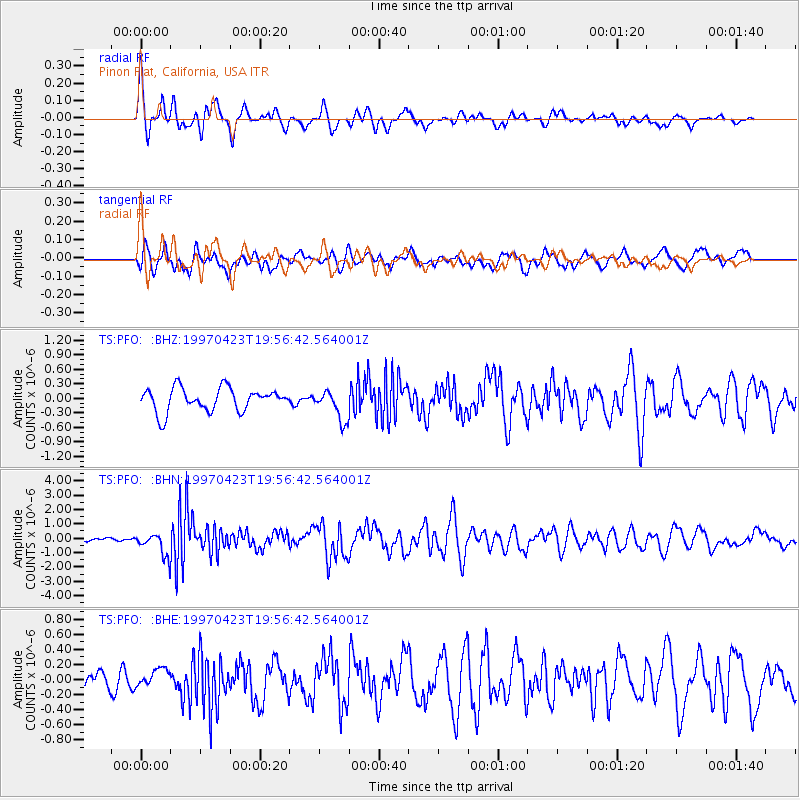
Signal To Noise
| Channel | StoN | STA | LTA |
| TS:PFO: :BHN:19970423T19:56:42.564001Z | 3.6470897 | 7.797979E-7 | 2.1381375E-7 |
| TS:PFO: :BHE:19970423T19:56:42.564001Z | 1.1985024 | 1.1559721E-7 | 9.645138E-8 |
| TS:PFO: :BHZ:19970423T19:56:42.564001Z | 1.292687 | 3.0896547E-7 | 2.3901026E-7 |
| Arrivals |
| Ps | 3.5 SECOND |
| PpPs | 12 SECOND |
| PsPs/PpSs | 15 SECOND |


