You are here: Home > Network List > IW - Intermountain West Stations List
> Station MOOW Moose Ponds, Wyoming, USA > Earthquake Result Viewer
MOOW Moose Ponds, Wyoming, USA - Earthquake Result Viewer
| Earthquake location: |
Off Coast Of Central Chile |
| Earthquake latitude/longitude: |
-33.0/-72.0 |
| Earthquake time(UTC): |
2017/04/24 (114) 21:38:24 GMT |
| Earthquake Depth: |
33 km |
| Earthquake Magnitude: |
6.7 Mi |
| Earthquake Catalog/Contributor: |
NEIC PDE/at |
|
| Network: |
IW Intermountain West |
| Station: |
MOOW Moose Ponds, Wyoming, USA |
| Lat/Lon: |
43.75 N/110.74 W |
| Elevation: |
2128 m |
|
| Distance: |
84.2 deg |
| Az: |
332.877 deg |
| Baz: |
148.085 deg |
| Ray Param: |
0.0456243 |
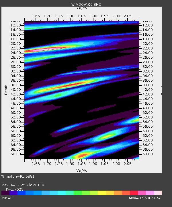
| Estimated Moho Depth: |
22.25 km |
| Estimated Crust Vp/Vs: |
1.70 |
| Assumed Crust Vp: |
6.207 km/s |
| Estimated Crust Vs: |
3.646 km/s |
| Estimated Crust Poisson's Ratio: |
0.24 |
|
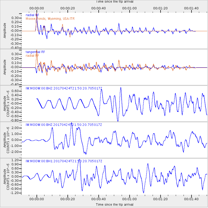
| Radial Match: |
91.0881 % |
| Radial Bump: |
400 |
| Transverse Match: |
72.35919 % |
| Transverse Bump: |
400 |
| SOD ConfigId: |
2028011 |
| Insert Time: |
2017-05-08 21:41:38.370 +0000 |
| GWidth: |
2.5 |
| Max Bumps: |
400 |
| Tol: |
0.001 |
|
Signal To Noise
| Channel | StoN | STA | LTA |
| IW:MOOW:00:BHZ:20170424T21:50:20.705017Z | 0.39999703 | 7.849364E-8 | 1.9623556E-7 |
| IW:MOOW:00:BH1:20170424T21:50:20.705017Z | 1.9381739 | 1.8383318E-7 | 9.484865E-8 |
| IW:MOOW:00:BH2:20170424T21:50:20.705017Z | 0.7290389 | 1.262199E-7 | 1.7313191E-7 |
| Arrivals |
| Ps | 2.6 SECOND |
| PpPs | 9.5 SECOND |
| PsPs/PpSs | 12 SECOND |


