You are here: Home > Network List > NM - Cooperative New Madrid Seismic Network Stations List
> Station PEBM Pemiscot Bayou,MO > Earthquake Result Viewer
PEBM Pemiscot Bayou,MO - Earthquake Result Viewer
| Earthquake location: |
Off Coast Of Central Chile |
| Earthquake latitude/longitude: |
-33.0/-72.0 |
| Earthquake time(UTC): |
2017/04/24 (114) 21:38:24 GMT |
| Earthquake Depth: |
33 km |
| Earthquake Magnitude: |
6.7 Mi |
| Earthquake Catalog/Contributor: |
NEIC PDE/at |
|
| Network: |
NM Cooperative New Madrid Seismic Network |
| Station: |
PEBM Pemiscot Bayou,MO |
| Lat/Lon: |
36.11 N/89.86 W |
| Elevation: |
76 m |
|
| Distance: |
70.8 deg |
| Az: |
344.748 deg |
| Baz: |
164.157 deg |
| Ray Param: |
0.05472133 |
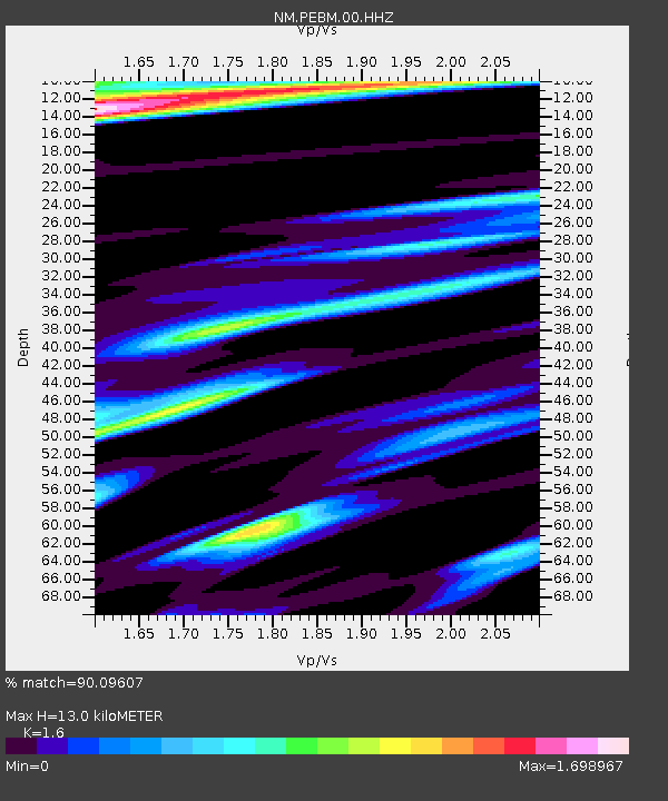
| Estimated Moho Depth: |
13.0 km |
| Estimated Crust Vp/Vs: |
1.60 |
| Assumed Crust Vp: |
6.444 km/s |
| Estimated Crust Vs: |
4.027 km/s |
| Estimated Crust Poisson's Ratio: |
0.18 |
|
| Radial Match: |
90.09607 % |
| Radial Bump: |
400 |
| Transverse Match: |
73.555435 % |
| Transverse Bump: |
397 |
| SOD ConfigId: |
2028011 |
| Insert Time: |
2017-05-08 21:42:04.226 +0000 |
| GWidth: |
2.5 |
| Max Bumps: |
400 |
| Tol: |
0.001 |
|

Signal To Noise
| Channel | StoN | STA | LTA |
| NM:PEBM:00:HHZ:20170424T21:49:06.000Z | 0.8323294 | 3.5554154E-7 | 4.2716448E-7 |
| NM:PEBM:00:HHN:20170424T21:49:06.000Z | 1.0221725 | 8.8207224E-7 | 8.6293875E-7 |
| NM:PEBM:00:HHE:20170424T21:49:06.000Z | 1.341352 | 1.0848231E-6 | 8.087535E-7 |
| Arrivals |
| Ps | 1.3 SECOND |
| PpPs | 5.0 SECOND |
| PsPs/PpSs | 6.3 SECOND |


