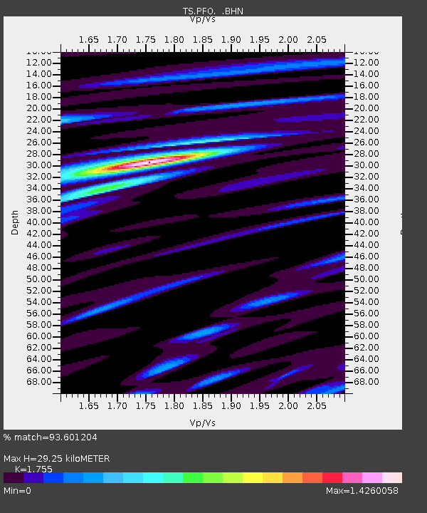
PFO Pinon Flat, California, USA - Earthquake Result Viewer
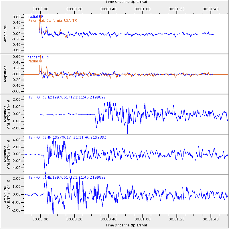
Earthquake location: Andreanof Islands, Aleutian Is.
Earthquake latitude/longitude: 51.3/-179.3
Earthquake time(UTC): 1997/06/17 (168) 21:03:40 GMT
Earthquake Depth: 33 km
Earthquake Magnitude: 6.4 MB, 6.3 MS, 6.4 UNKNOWN, 6.6 ML
Earthquake Catalog/Contributor: WHDF/NEIC
Network: TS TERRAscope (Southern California Seismic Network)
Station: PFO Pinon Flat, California, USA
Lat/Lon: 33.61 N/116.46 W
Elevation: 1280 m
Distance: 48.1 deg
Az: 86.211 deg
Baz: 311.422 deg
Ray Param: 0.06950776
Estimated Moho Depth: 29.25 km
Estimated Crust Vp/Vs: 1.75
Assumed Crust Vp: 6.264 km/s
Estimated Crust Vs: 3.569 km/s
Estimated Crust Poisson's Ratio: 0.26
Radial Match: 93.601204 %
Radial Bump: 400
Transverse Match: 85.61767 %
Transverse Bump: 400
SOD ConfigId: 4480
Insert Time: 2010-02-26 14:40:51.640 +0000
GWidth: 2.5
Max Bumps: 400
Tol: 0.001

Signal To Noise

ChannelStoNSTALTA
TS:PFO: :BHN:19970617T21:11:46.219989Z24.580262.3130672E-69.410263E-8
TS:PFO: :BHE:19970617T21:11:46.219989Z14.6025229.827826E-76.730225E-8
TS:PFO: :BHZ:19970617T21:11:46.219989Z13.9336197.5629424E-75.427838E-8
Arrivals
Ps3.7 SECOND
PpPs12 SECOND
PsPs/PpSs16 SECOND