You are here: Home > Network List > TS - TERRAscope (Southern California Seismic Network) Stations List
> Station PFO Pinon Flat, California, USA > Earthquake Result Viewer
PFO Pinon Flat, California, USA - Earthquake Result Viewer
| Earthquake location: |
Near Coast Of Central Chile |
| Earthquake latitude/longitude: |
-30.1/-71.9 |
| Earthquake time(UTC): |
1997/07/06 (187) 09:54:00 GMT |
| Earthquake Depth: |
19 km |
| Earthquake Magnitude: |
5.8 MB, 6.5 MS, 6.8 UNKNOWN, 6.4 ME |
| Earthquake Catalog/Contributor: |
WHDF/NEIC |
|
| Network: |
TS TERRAscope (Southern California Seismic Network) |
| Station: |
PFO Pinon Flat, California, USA |
| Lat/Lon: |
33.61 N/116.46 W |
| Elevation: |
1280 m |
|
| Distance: |
76.1 deg |
| Az: |
322.875 deg |
| Baz: |
141.17 deg |
| Ray Param: |
0.051225238 |
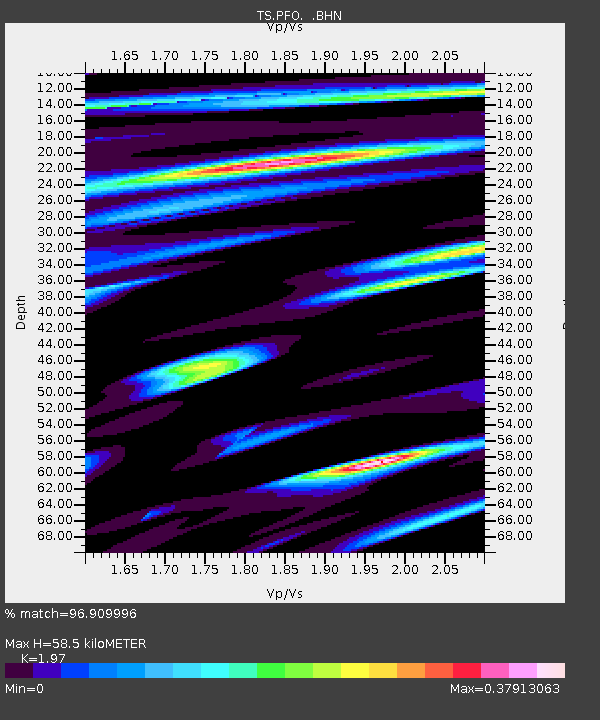
| Estimated Moho Depth: |
58.5 km |
| Estimated Crust Vp/Vs: |
1.97 |
| Assumed Crust Vp: |
6.264 km/s |
| Estimated Crust Vs: |
3.18 km/s |
| Estimated Crust Poisson's Ratio: |
0.33 |
|
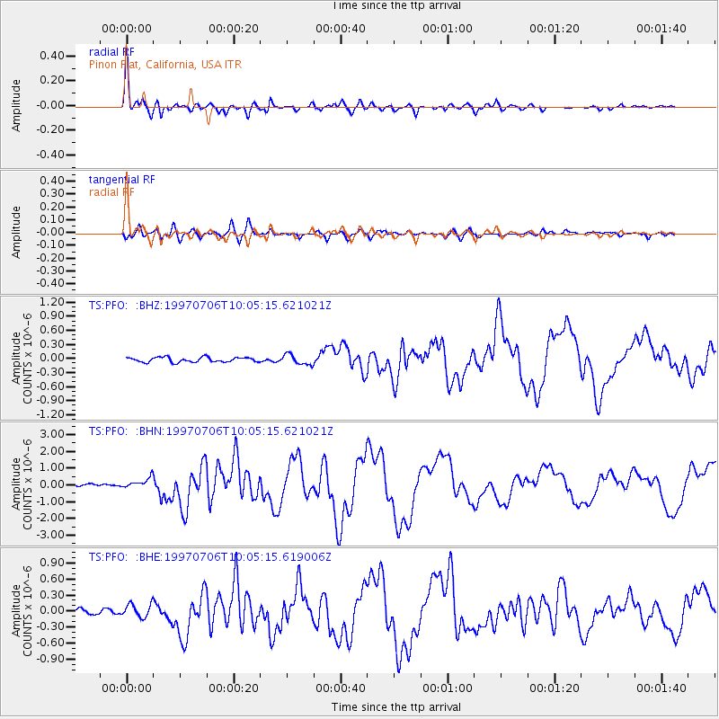
| Radial Match: |
96.909996 % |
| Radial Bump: |
322 |
| Transverse Match: |
82.38098 % |
| Transverse Bump: |
400 |
| SOD ConfigId: |
4480 |
| Insert Time: |
2010-02-26 14:40:52.542 +0000 |
| GWidth: |
2.5 |
| Max Bumps: |
400 |
| Tol: |
0.001 |
|
Signal To Noise
| Channel | StoN | STA | LTA |
| TS:PFO: :BHN:19970706T10:05:15.621021Z | 4.686945 | 3.1111247E-7 | 6.637852E-8 |
| TS:PFO: :BHE:19970706T10:05:15.619006Z | 1.9816173 | 1.2991063E-7 | 6.5557884E-8 |
| TS:PFO: :BHZ:19970706T10:05:15.621021Z | 2.1208825 | 1.0808998E-7 | 5.0964626E-8 |
| Arrivals |
| Ps | 9.3 SECOND |
| PpPs | 27 SECOND |
| PsPs/PpSs | 36 SECOND |


