You are here: Home > Network List > UU - University of Utah Regional Network Stations List
> Station FORU South Mineral Mountains, UT, USA > Earthquake Result Viewer
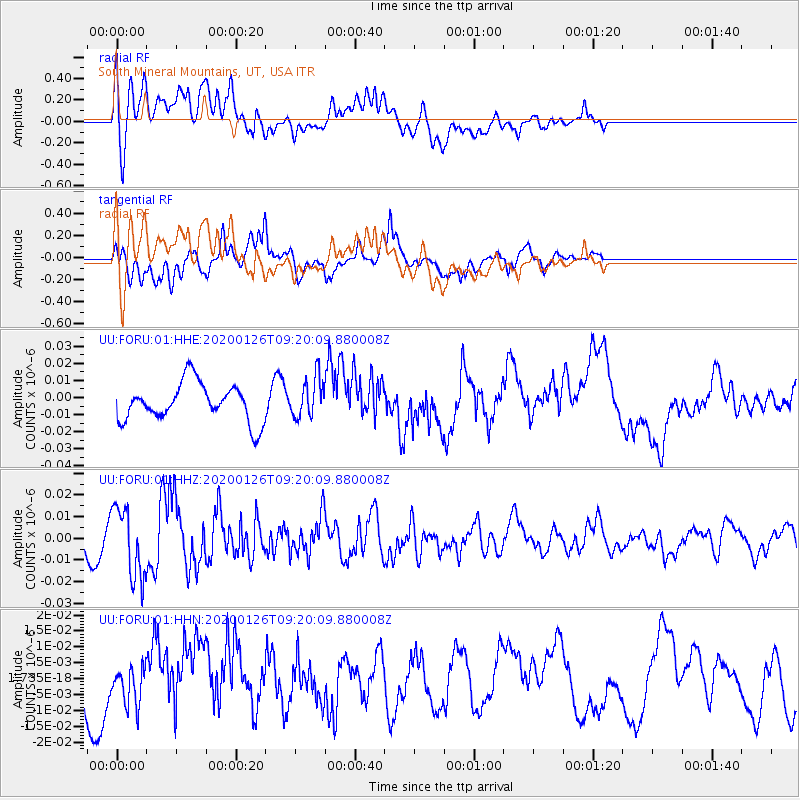
FORU South Mineral Mountains, UT, USA - Earthquake Result Viewer
*The percent match for this event was below the threshold and hence no stack was calculated.
| Earthquake location: |
Andreanof Islands, Aleutian Is. |
| Earthquake latitude/longitude: |
51.2/-179.8 |
| Earthquake time(UTC): |
2020/01/26 (026) 09:12:07 GMT |
| Earthquake Depth: |
24 km |
| Earthquake Magnitude: |
5.6 Mww |
| Earthquake Catalog/Contributor: |
NEIC PDE/us |
|
| Network: |
UU University of Utah Regional Network |
| Station: |
FORU South Mineral Mountains, UT, USA |
| Lat/Lon: |
38.46 N/112.86 W |
| Elevation: |
1840 m |
|
| Distance: |
47.5 deg |
| Az: |
78.251 deg |
| Baz: |
308.37 deg |
| Ray Param: |
$rayparam |
*The percent match for this event was below the threshold and hence was not used in the summary stack. |
|
| Radial Match: |
37.93973 % |
| Radial Bump: |
400 |
| Transverse Match: |
50.283516 % |
| Transverse Bump: |
386 |
| SOD ConfigId: |
20465011 |
| Insert Time: |
2020-02-09 09:34:37.619 +0000 |
| GWidth: |
2.5 |
| Max Bumps: |
400 |
| Tol: |
0.001 |
|
Signal To Noise
| Channel | StoN | STA | LTA |
| UU:FORU:01:HHZ:20200126T09:20:09.880008Z | 2.459608 | 1.6123105E-8 | 6.555152E-9 |
| UU:FORU:01:HHN:20200126T09:20:09.880008Z | 1.0993596 | 6.1288197E-9 | 5.5748997E-9 |
| UU:FORU:01:HHE:20200126T09:20:09.880008Z | 1.0455215 | 1.1551E-8 | 1.1048075E-8 |
| Arrivals |
| Ps | |
| PpPs | |
| PsPs/PpSs | |


