You are here: Home > Network List > TS - TERRAscope (Southern California Seismic Network) Stations List
> Station PFO Pinon Flat, California, USA > Earthquake Result Viewer
PFO Pinon Flat, California, USA - Earthquake Result Viewer

| Earthquake location: |
Southeast Of Loyalty Islands |
| Earthquake latitude/longitude: |
-23.0/169.9 |
| Earthquake time(UTC): |
1995/05/16 (136) 20:12:45 GMT |
| Earthquake Depth: |
33 km |
| Earthquake Magnitude: |
6.8 MB, 7.7 MS, 7.7 UNKNOWN, 7.7 MW |
| Earthquake Catalog/Contributor: |
WHDF/NEIC |
|
| Network: |
TS TERRAscope (Southern California Seismic Network) |
| Station: |
PFO Pinon Flat, California, USA |
| Lat/Lon: |
33.61 N/116.46 W |
| Elevation: |
1280 m |
|
| Distance: |
89.9 deg |
| Az: |
53.207 deg |
| Baz: |
242.141 deg |
| Ray Param: |
0.04170985 |
| Estimated Moho Depth: |
29.5 km |
| Estimated Crust Vp/Vs: |
1.64 |
| Assumed Crust Vp: |
6.264 km/s |
| Estimated Crust Vs: |
3.808 km/s |
| Estimated Crust Poisson's Ratio: |
0.21 |
|
| Radial Match: |
95.619736 % |
| Radial Bump: |
331 |
| Transverse Match: |
89.57436 % |
| Transverse Bump: |
400 |
| SOD ConfigId: |
4480 |
| Insert Time: |
2010-02-26 14:40:54.336 +0000 |
| GWidth: |
2.5 |
| Max Bumps: |
400 |
| Tol: |
0.001 |
|
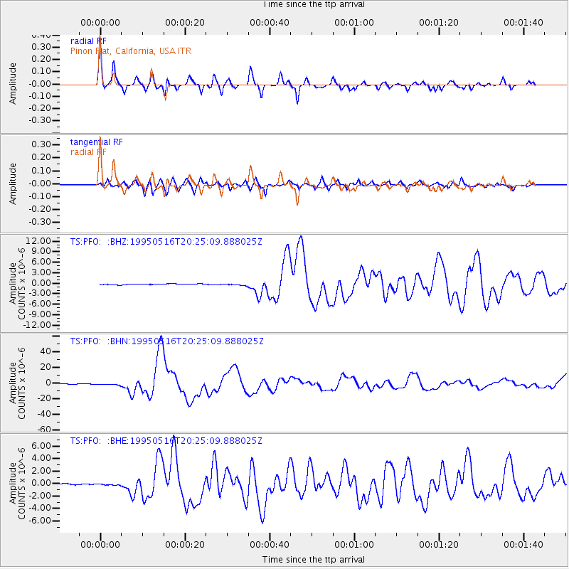
Signal To Noise
| Channel | StoN | STA | LTA |
| TS:PFO: :BHN:19950516T20:25:09.888025Z | 4.27318 | 9.081369E-7 | 2.1252016E-7 |
| TS:PFO: :BHE:19950516T20:25:09.888025Z | 0.9899013 | 9.665397E-8 | 9.7640005E-8 |
| TS:PFO: :BHZ:19950516T20:25:09.888025Z | 2.0709126 | 2.5031588E-7 | 1.2087226E-7 |
| Arrivals |
| Ps | 3.1 SECOND |
| PpPs | 12 SECOND |
| PsPs/PpSs | 15 SECOND |


