You are here: Home > Network List > UW - Pacific Northwest Regional Seismic Network Stations List
> Station IRON Crane, OR, USA > Earthquake Result Viewer
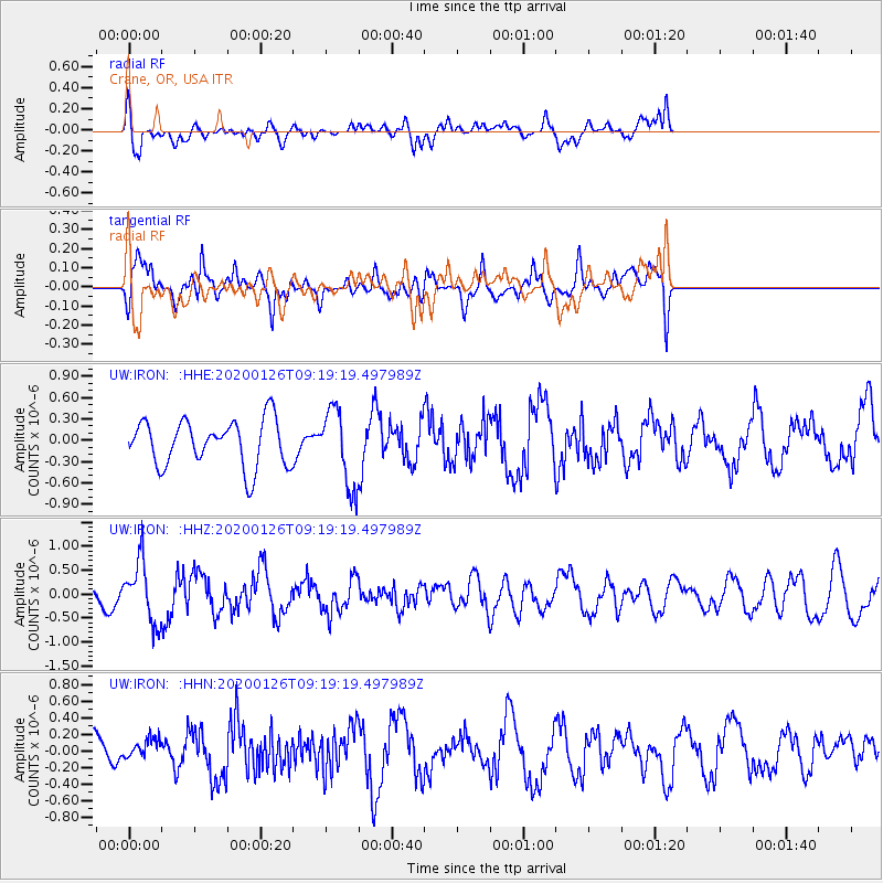
IRON Crane, OR, USA - Earthquake Result Viewer
*The percent match for this event was below the threshold and hence no stack was calculated.
| Earthquake location: |
Andreanof Islands, Aleutian Is. |
| Earthquake latitude/longitude: |
51.2/-179.8 |
| Earthquake time(UTC): |
2020/01/26 (026) 09:12:07 GMT |
| Earthquake Depth: |
24 km |
| Earthquake Magnitude: |
5.6 Mww |
| Earthquake Catalog/Contributor: |
NEIC PDE/us |
|
| Network: |
UW Pacific Northwest Regional Seismic Network |
| Station: |
IRON Crane, OR, USA |
| Lat/Lon: |
43.36 N/118.47 W |
| Elevation: |
1226 m |
|
| Distance: |
41.2 deg |
| Az: |
76.137 deg |
| Baz: |
303.191 deg |
| Ray Param: |
$rayparam |
*The percent match for this event was below the threshold and hence was not used in the summary stack. |
|
| Radial Match: |
61.65166 % |
| Radial Bump: |
400 |
| Transverse Match: |
58.89798 % |
| Transverse Bump: |
400 |
| SOD ConfigId: |
20465011 |
| Insert Time: |
2020-02-09 09:35:28.778 +0000 |
| GWidth: |
2.5 |
| Max Bumps: |
400 |
| Tol: |
0.001 |
|
Signal To Noise
| Channel | StoN | STA | LTA |
| UW:IRON: :HHZ:20200126T09:19:19.497989Z | 3.0513628 | 6.3385374E-7 | 2.0772809E-7 |
| UW:IRON: :HHN:20200126T09:19:19.497989Z | 0.45506933 | 1.2011851E-7 | 2.639565E-7 |
| UW:IRON: :HHE:20200126T09:19:19.497989Z | 1.668215 | 5.417632E-7 | 3.2475623E-7 |
| Arrivals |
| Ps | |
| PpPs | |
| PsPs/PpSs | |


