You are here: Home > Network List > TS - TERRAscope (Southern California Seismic Network) Stations List
> Station PFO Pinon Flat, California, USA > Earthquake Result Viewer
PFO Pinon Flat, California, USA - Earthquake Result Viewer
| Earthquake location: |
Central East Pacific Rise |
| Earthquake latitude/longitude: |
-4.4/-105.7 |
| Earthquake time(UTC): |
1997/08/15 (227) 07:37:49 GMT |
| Earthquake Depth: |
10 km |
| Earthquake Magnitude: |
5.3 MB, 5.8 MS, 6.2 UNKNOWN, 6.1 MW |
| Earthquake Catalog/Contributor: |
WHDF/NEIC |
|
| Network: |
TS TERRAscope (Southern California Seismic Network) |
| Station: |
PFO Pinon Flat, California, USA |
| Lat/Lon: |
33.61 N/116.46 W |
| Elevation: |
1280 m |
|
| Distance: |
39.1 deg |
| Az: |
345.708 deg |
| Baz: |
162.845 deg |
| Ray Param: |
0.075166024 |
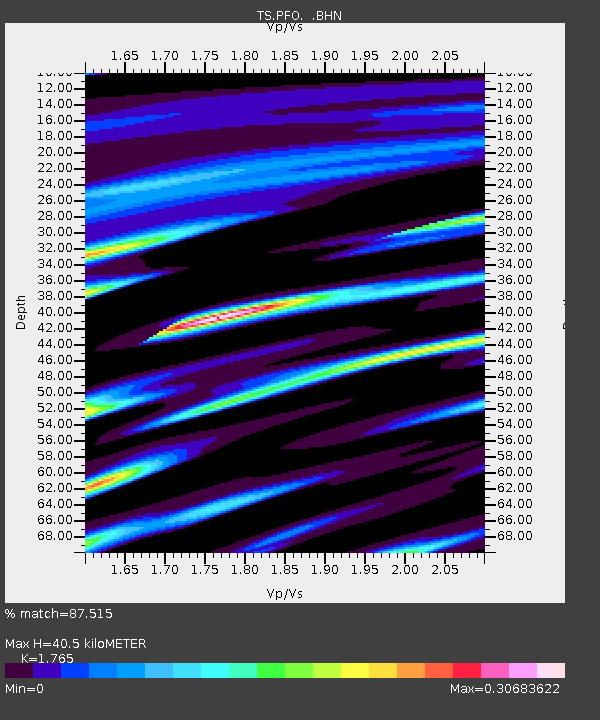
| Estimated Moho Depth: |
40.5 km |
| Estimated Crust Vp/Vs: |
1.76 |
| Assumed Crust Vp: |
6.264 km/s |
| Estimated Crust Vs: |
3.549 km/s |
| Estimated Crust Poisson's Ratio: |
0.26 |
|
| Radial Match: |
87.515 % |
| Radial Bump: |
227 |
| Transverse Match: |
67.17574 % |
| Transverse Bump: |
400 |
| SOD ConfigId: |
4480 |
| Insert Time: |
2010-02-26 14:40:56.975 +0000 |
| GWidth: |
2.5 |
| Max Bumps: |
400 |
| Tol: |
0.001 |
|

Signal To Noise
| Channel | StoN | STA | LTA |
| TS:PFO: :BHN:19970815T07:44:45.700012Z | 2.7622685 | 1.92418E-7 | 6.9659414E-8 |
| TS:PFO: :BHE:19970815T07:44:45.699005Z | 1.7231412 | 1.0431377E-7 | 6.053698E-8 |
| TS:PFO: :BHZ:19970815T07:44:45.700012Z | 1.1204727 | 7.379435E-8 | 6.5860014E-8 |
| Arrivals |
| Ps | 5.3 SECOND |
| PpPs | 17 SECOND |
| PsPs/PpSs | 22 SECOND |


