You are here: Home > Network List > TS - TERRAscope (Southern California Seismic Network) Stations List
> Station PFO Pinon Flat, California, USA > Earthquake Result Viewer
PFO Pinon Flat, California, USA - Earthquake Result Viewer
| Earthquake location: |
Near Coast Of Northern Chile |
| Earthquake latitude/longitude: |
-23.4/-70.3 |
| Earthquake time(UTC): |
1995/07/30 (211) 05:11:23 GMT |
| Earthquake Depth: |
47 km |
| Earthquake Magnitude: |
6.6 MB, 7.3 MS, 7.2 UNKNOWN, 8.1 MW |
| Earthquake Catalog/Contributor: |
WHDF/NEIC |
|
| Network: |
TS TERRAscope (Southern California Seismic Network) |
| Station: |
PFO Pinon Flat, California, USA |
| Lat/Lon: |
33.61 N/116.46 W |
| Elevation: |
1280 m |
|
| Distance: |
71.7 deg |
| Az: |
320.665 deg |
| Baz: |
135.736 deg |
| Ray Param: |
0.05406839 |
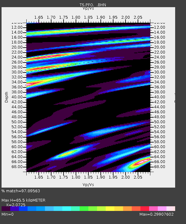
| Estimated Moho Depth: |
65.5 km |
| Estimated Crust Vp/Vs: |
2.07 |
| Assumed Crust Vp: |
6.264 km/s |
| Estimated Crust Vs: |
3.022 km/s |
| Estimated Crust Poisson's Ratio: |
0.35 |
|
| Radial Match: |
97.89563 % |
| Radial Bump: |
275 |
| Transverse Match: |
90.16796 % |
| Transverse Bump: |
400 |
| SOD ConfigId: |
4480 |
| Insert Time: |
2010-02-26 14:41:01.335 +0000 |
| GWidth: |
2.5 |
| Max Bumps: |
400 |
| Tol: |
0.001 |
|

Signal To Noise
| Channel | StoN | STA | LTA |
| TS:PFO: :BHN:19950730T05:22:09.627014Z | 5.009917 | 6.6982096E-7 | 1.3369902E-7 |
| TS:PFO: :BHE:19950730T05:22:09.627014Z | 2.2434154 | 1.8609079E-7 | 8.294977E-8 |
| TS:PFO: :BHZ:19950730T05:22:09.629028Z | 2.0346372 | 1.6422045E-7 | 8.07124E-8 |
| Arrivals |
| Ps | 12 SECOND |
| PpPs | 31 SECOND |
| PsPs/PpSs | 43 SECOND |


