You are here: Home > Network List > TS - TERRAscope (Southern California Seismic Network) Stations List
> Station PFO Pinon Flat, California, USA > Earthquake Result Viewer
PFO Pinon Flat, California, USA - Earthquake Result Viewer
| Earthquake location: |
Mariana Islands |
| Earthquake latitude/longitude: |
18.9/145.0 |
| Earthquake time(UTC): |
1995/08/24 (236) 01:55:34 GMT |
| Earthquake Depth: |
589 km |
| Earthquake Magnitude: |
5.9 MB, 6.2 UNKNOWN, 6.2 MW |
| Earthquake Catalog/Contributor: |
WHDF/NEIC |
|
| Network: |
TS TERRAscope (Southern California Seismic Network) |
| Station: |
PFO Pinon Flat, California, USA |
| Lat/Lon: |
33.61 N/116.46 W |
| Elevation: |
1280 m |
|
| Distance: |
86.6 deg |
| Az: |
55.755 deg |
| Baz: |
290.336 deg |
| Ray Param: |
0.04224205 |
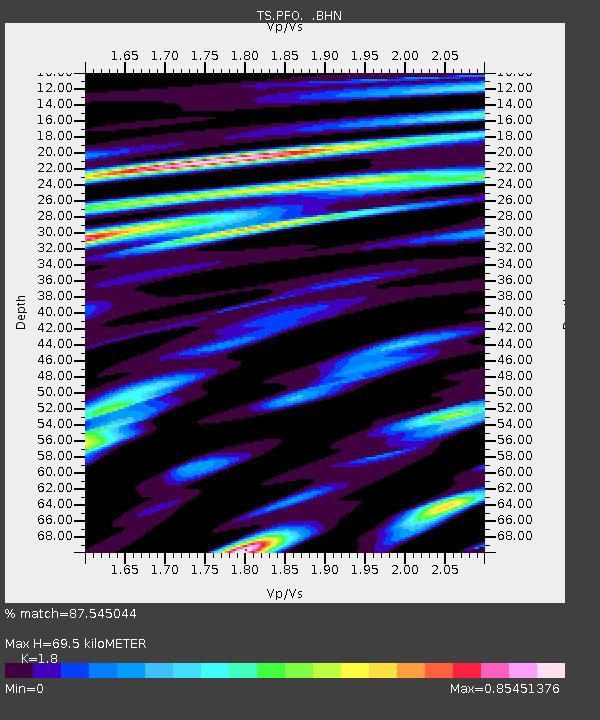
| Estimated Moho Depth: |
69.5 km |
| Estimated Crust Vp/Vs: |
1.80 |
| Assumed Crust Vp: |
6.264 km/s |
| Estimated Crust Vs: |
3.48 km/s |
| Estimated Crust Poisson's Ratio: |
0.28 |
|
| Radial Match: |
87.545044 % |
| Radial Bump: |
400 |
| Transverse Match: |
82.51846 % |
| Transverse Bump: |
400 |
| SOD ConfigId: |
4480 |
| Insert Time: |
2010-02-26 14:41:05.800 +0000 |
| GWidth: |
2.5 |
| Max Bumps: |
400 |
| Tol: |
0.001 |
|

Signal To Noise
| Channel | StoN | STA | LTA |
| TS:PFO: :BHN:19950824T02:06:45.047998Z | 18.580866 | 1.4123456E-6 | 7.601075E-8 |
| TS:PFO: :BHE:19950824T02:06:45.047998Z | 3.5181599 | 1.5636478E-7 | 4.4445045E-8 |
| TS:PFO: :BHZ:19950824T02:06:45.047998Z | 5.435526 | 3.8865278E-7 | 7.1502335E-8 |
| Arrivals |
| Ps | 9.1 SECOND |
| PpPs | 30 SECOND |
| PsPs/PpSs | 40 SECOND |


