You are here: Home > Network List > TS - TERRAscope (Southern California Seismic Network) Stations List
> Station PFO Pinon Flat, California, USA > Earthquake Result Viewer
PFO Pinon Flat, California, USA - Earthquake Result Viewer
| Earthquake location: |
Peru-Ecuador Border Region |
| Earthquake latitude/longitude: |
-2.8/-77.9 |
| Earthquake time(UTC): |
1995/10/03 (276) 12:45:00 GMT |
| Earthquake Depth: |
33 km |
| Earthquake Magnitude: |
6.0 MB, 6.1 MS, 5.9 UNKNOWN, 6.4 MW |
| Earthquake Catalog/Contributor: |
WHDF/NEIC |
|
| Network: |
TS TERRAscope (Southern California Seismic Network) |
| Station: |
PFO Pinon Flat, California, USA |
| Lat/Lon: |
33.61 N/116.46 W |
| Elevation: |
1280 m |
|
| Distance: |
51.3 deg |
| Az: |
318.217 deg |
| Baz: |
127.111 deg |
| Ray Param: |
0.067426346 |
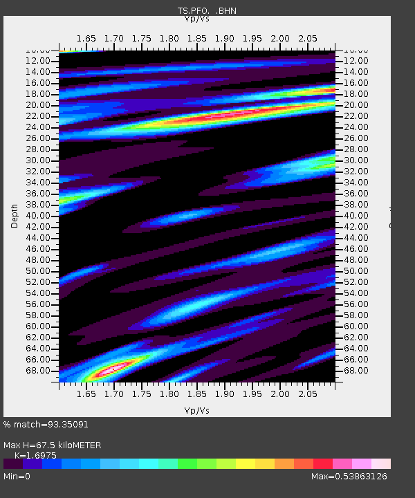
| Estimated Moho Depth: |
67.5 km |
| Estimated Crust Vp/Vs: |
1.70 |
| Assumed Crust Vp: |
6.264 km/s |
| Estimated Crust Vs: |
3.69 km/s |
| Estimated Crust Poisson's Ratio: |
0.23 |
|
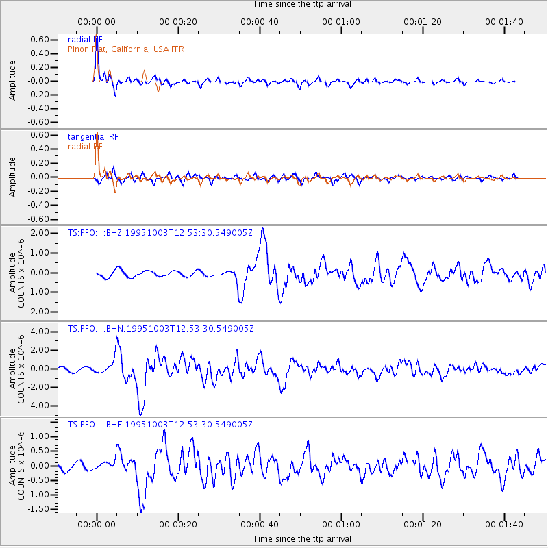
| Radial Match: |
93.35091 % |
| Radial Bump: |
281 |
| Transverse Match: |
81.342 % |
| Transverse Bump: |
400 |
| SOD ConfigId: |
4480 |
| Insert Time: |
2010-02-26 14:41:10.737 +0000 |
| GWidth: |
2.5 |
| Max Bumps: |
400 |
| Tol: |
0.001 |
|
Signal To Noise
| Channel | StoN | STA | LTA |
| TS:PFO: :BHN:19951003T12:53:30.549005Z | 3.916163 | 8.3613E-7 | 2.1350746E-7 |
| TS:PFO: :BHE:19951003T12:53:30.549005Z | 1.4479669 | 1.5627354E-7 | 1.07926176E-7 |
| TS:PFO: :BHZ:19951003T12:53:30.549005Z | 1.7735907 | 2.7850828E-7 | 1.5703075E-7 |
| Arrivals |
| Ps | 7.9 SECOND |
| PpPs | 27 SECOND |
| PsPs/PpSs | 35 SECOND |


