You are here: Home > Network List > AV - Alaska Volcano Observatory Stations List
> Station PLBL Mt. Peulik Volcano, Alaska > Earthquake Result Viewer
PLBL Mt. Peulik Volcano, Alaska - Earthquake Result Viewer
*The percent match for this event was below the threshold and hence no stack was calculated.
| Earthquake location: |
Solomon Islands |
| Earthquake latitude/longitude: |
-10.1/161.0 |
| Earthquake time(UTC): |
2020/01/27 (027) 05:02:01 GMT |
| Earthquake Depth: |
18 km |
| Earthquake Magnitude: |
6.3 Mww |
| Earthquake Catalog/Contributor: |
NEIC PDE/us |
|
| Network: |
AV Alaska Volcano Observatory |
| Station: |
PLBL Mt. Peulik Volcano, Alaska |
| Lat/Lon: |
57.70 N/156.82 W |
| Elevation: |
461 m |
|
| Distance: |
75.8 deg |
| Az: |
21.819 deg |
| Baz: |
222.97 deg |
| Ray Param: |
$rayparam |
*The percent match for this event was below the threshold and hence was not used in the summary stack. |
|
| Radial Match: |
64.42835 % |
| Radial Bump: |
400 |
| Transverse Match: |
66.26962 % |
| Transverse Bump: |
400 |
| SOD ConfigId: |
20465011 |
| Insert Time: |
2020-02-10 05:06:08.324 +0000 |
| GWidth: |
2.5 |
| Max Bumps: |
400 |
| Tol: |
0.001 |
|
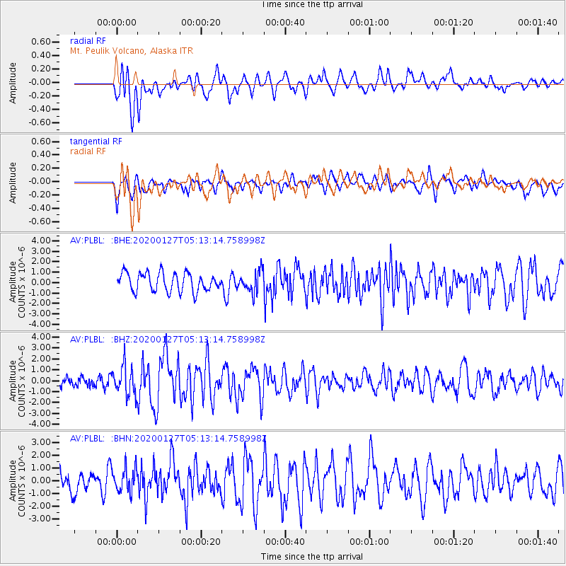
Signal To Noise
| Channel | StoN | STA | LTA |
| AV:PLBL: :BHZ:20200127T05:13:14.758998Z | 2.02569 | 1.3740428E-6 | 6.783085E-7 |
| AV:PLBL: :BHN:20200127T05:13:14.758998Z | 1.1954049 | 9.4356966E-7 | 7.8933056E-7 |
| AV:PLBL: :BHE:20200127T05:13:14.758998Z | 1.158256 | 1.015143E-6 | 8.764409E-7 |
| Arrivals |
| Ps | |
| PpPs | |
| PsPs/PpSs | |


