You are here: Home > Network List > CI - Caltech Regional Seismic Network Stations List
> Station GLA Glamis, Glamis, CA, USA > Earthquake Result Viewer
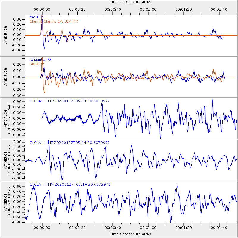
GLA Glamis, Glamis, CA, USA - Earthquake Result Viewer
*The percent match for this event was below the threshold and hence no stack was calculated.
| Earthquake location: |
Solomon Islands |
| Earthquake latitude/longitude: |
-10.1/161.0 |
| Earthquake time(UTC): |
2020/01/27 (027) 05:02:01 GMT |
| Earthquake Depth: |
18 km |
| Earthquake Magnitude: |
6.3 Mww |
| Earthquake Catalog/Contributor: |
NEIC PDE/us |
|
| Network: |
CI Caltech Regional Seismic Network |
| Station: |
GLA Glamis, Glamis, CA, USA |
| Lat/Lon: |
33.05 N/114.83 W |
| Elevation: |
610 m |
|
| Distance: |
90.6 deg |
| Az: |
56.67 deg |
| Baz: |
258.41 deg |
| Ray Param: |
$rayparam |
*The percent match for this event was below the threshold and hence was not used in the summary stack. |
|
| Radial Match: |
60.804276 % |
| Radial Bump: |
400 |
| Transverse Match: |
56.200417 % |
| Transverse Bump: |
400 |
| SOD ConfigId: |
20465011 |
| Insert Time: |
2020-02-10 05:08:39.916 +0000 |
| GWidth: |
2.5 |
| Max Bumps: |
400 |
| Tol: |
0.001 |
|
Signal To Noise
| Channel | StoN | STA | LTA |
| CI:GLA: :HHZ:20200127T05:14:30.607997Z | 5.967927 | 8.431529E-7 | 1.4128071E-7 |
| CI:GLA: :HHN:20200127T05:14:30.607997Z | 0.93238443 | 3.3436507E-7 | 3.5861288E-7 |
| CI:GLA: :HHE:20200127T05:14:30.607997Z | 2.3786707 | 3.463714E-7 | 1.4561553E-7 |
| Arrivals |
| Ps | |
| PpPs | |
| PsPs/PpSs | |


