You are here: Home > Network List > IU - Global Seismograph Network (GSN - IRIS/USGS) Stations List
> Station CCM Cathedral Cave, Missouri, USA > Earthquake Result Viewer
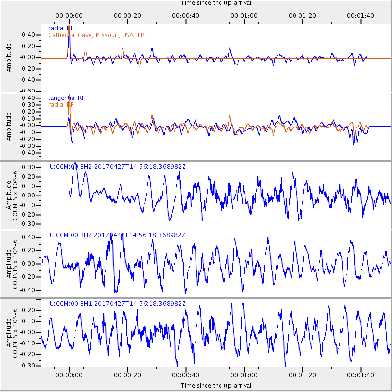
CCM Cathedral Cave, Missouri, USA - Earthquake Result Viewer
*The percent match for this event was below the threshold and hence no stack was calculated.
| Earthquake location: |
Rat Islands, Aleutian Islands |
| Earthquake latitude/longitude: |
51.3/178.6 |
| Earthquake time(UTC): |
2017/04/27 (117) 14:46:33 GMT |
| Earthquake Depth: |
19 km |
| Earthquake Magnitude: |
5.7 Mww |
| Earthquake Catalog/Contributor: |
NEIC PDE/us |
|
| Network: |
IU Global Seismograph Network (GSN - IRIS/USGS) |
| Station: |
CCM Cathedral Cave, Missouri, USA |
| Lat/Lon: |
38.06 N/91.24 W |
| Elevation: |
222 m |
|
| Distance: |
61.6 deg |
| Az: |
63.871 deg |
| Baz: |
314.385 deg |
| Ray Param: |
$rayparam |
*The percent match for this event was below the threshold and hence was not used in the summary stack. |
|
| Radial Match: |
60.232456 % |
| Radial Bump: |
400 |
| Transverse Match: |
43.304783 % |
| Transverse Bump: |
400 |
| SOD ConfigId: |
2028011 |
| Insert Time: |
2017-05-11 14:51:19.744 +0000 |
| GWidth: |
2.5 |
| Max Bumps: |
400 |
| Tol: |
0.001 |
|
Signal To Noise
| Channel | StoN | STA | LTA |
| IU:CCM:00:BHZ:20170427T14:56:18.368982Z | 0.79428744 | 1.0664523E-7 | 1.3426529E-7 |
| IU:CCM:00:BH1:20170427T14:56:18.368982Z | 0.940044 | 1.2294308E-7 | 1.3078439E-7 |
| IU:CCM:00:BH2:20170427T14:56:18.368982Z | 1.5015475 | 1.5612827E-7 | 1.0397824E-7 |
| Arrivals |
| Ps | |
| PpPs | |
| PsPs/PpSs | |


