You are here: Home > Network List > TS - TERRAscope (Southern California Seismic Network) Stations List
> Station PFO Pinon Flat, California, USA > Earthquake Result Viewer
PFO Pinon Flat, California, USA - Earthquake Result Viewer

| Earthquake location: |
Near Coast Of Central Chile |
| Earthquake latitude/longitude: |
-29.0/-71.5 |
| Earthquake time(UTC): |
1995/11/01 (305) 00:35:32 GMT |
| Earthquake Depth: |
20 km |
| Earthquake Magnitude: |
6.3 MB, 6.4 MS, 6.3 UNKNOWN, 6.7 MW |
| Earthquake Catalog/Contributor: |
WHDF/NEIC |
|
| Network: |
TS TERRAscope (Southern California Seismic Network) |
| Station: |
PFO Pinon Flat, California, USA |
| Lat/Lon: |
33.61 N/116.46 W |
| Elevation: |
1280 m |
|
| Distance: |
75.4 deg |
| Az: |
322.46 deg |
| Baz: |
140.22 deg |
| Ray Param: |
0.05168046 |
| Estimated Moho Depth: |
20.25 km |
| Estimated Crust Vp/Vs: |
1.98 |
| Assumed Crust Vp: |
6.264 km/s |
| Estimated Crust Vs: |
3.167 km/s |
| Estimated Crust Poisson's Ratio: |
0.33 |
|
| Radial Match: |
94.51789 % |
| Radial Bump: |
299 |
| Transverse Match: |
82.92371 % |
| Transverse Bump: |
400 |
| SOD ConfigId: |
4480 |
| Insert Time: |
2010-02-26 14:41:12.888 +0000 |
| GWidth: |
2.5 |
| Max Bumps: |
400 |
| Tol: |
0.001 |
|
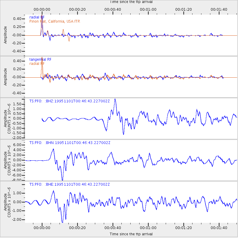
Signal To Noise
| Channel | StoN | STA | LTA |
| TS:PFO: :BHN:19951101T00:46:43.227002Z | 2.3164723 | 4.2643882E-7 | 1.8408976E-7 |
| TS:PFO: :BHE:19951101T00:46:43.227002Z | 1.231804 | 1.9509943E-7 | 1.5838513E-7 |
| TS:PFO: :BHZ:19951101T00:46:43.227002Z | 1.282706 | 1.2667427E-7 | 9.875549E-8 |
| Arrivals |
| Ps | 3.2 SECOND |
| PpPs | 9.4 SECOND |
| PsPs/PpSs | 13 SECOND |


