You are here: Home > Network List > IU - Global Seismograph Network (GSN - IRIS/USGS) Stations List
> Station RSSD Black Hills, South Dakota, USA > Earthquake Result Viewer
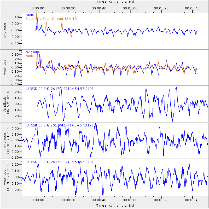
RSSD Black Hills, South Dakota, USA - Earthquake Result Viewer
*The percent match for this event was below the threshold and hence no stack was calculated.
| Earthquake location: |
Rat Islands, Aleutian Islands |
| Earthquake latitude/longitude: |
51.3/178.6 |
| Earthquake time(UTC): |
2017/04/27 (117) 14:46:33 GMT |
| Earthquake Depth: |
19 km |
| Earthquake Magnitude: |
5.7 Mww |
| Earthquake Catalog/Contributor: |
NEIC PDE/us |
|
| Network: |
IU Global Seismograph Network (GSN - IRIS/USGS) |
| Station: |
RSSD Black Hills, South Dakota, USA |
| Lat/Lon: |
44.12 N/104.04 W |
| Elevation: |
2090 m |
|
| Distance: |
50.3 deg |
| Az: |
65.975 deg |
| Baz: |
307.163 deg |
| Ray Param: |
$rayparam |
*The percent match for this event was below the threshold and hence was not used in the summary stack. |
|
| Radial Match: |
53.891712 % |
| Radial Bump: |
400 |
| Transverse Match: |
51.706093 % |
| Transverse Bump: |
306 |
| SOD ConfigId: |
2028011 |
| Insert Time: |
2017-05-11 14:51:32.178 +0000 |
| GWidth: |
2.5 |
| Max Bumps: |
400 |
| Tol: |
0.001 |
|
Signal To Noise
| Channel | StoN | STA | LTA |
| IU:RSSD:00:BHZ:20170427T14:54:57.919Z | 2.0944269 | 1.786304E-7 | 8.5288434E-8 |
| IU:RSSD:00:BH1:20170427T14:54:57.919Z | 2.339807 | 1.3027548E-7 | 5.5677873E-8 |
| IU:RSSD:00:BH2:20170427T14:54:57.919Z | 0.70350707 | 8.3775035E-8 | 1.1908201E-7 |
| Arrivals |
| Ps | |
| PpPs | |
| PsPs/PpSs | |


