You are here: Home > Network List > TA - USArray Transportable Network (new EarthScope stations) Stations List
> Station A22K Sinclair Lake, AK, USA > Earthquake Result Viewer
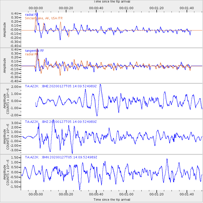
A22K Sinclair Lake, AK, USA - Earthquake Result Viewer
*The percent match for this event was below the threshold and hence no stack was calculated.
| Earthquake location: |
Solomon Islands |
| Earthquake latitude/longitude: |
-10.1/161.0 |
| Earthquake time(UTC): |
2020/01/27 (027) 05:02:01 GMT |
| Earthquake Depth: |
18 km |
| Earthquake Magnitude: |
6.3 Mww |
| Earthquake Catalog/Contributor: |
NEIC PDE/us |
|
| Network: |
TA USArray Transportable Network (new EarthScope stations) |
| Station: |
A22K Sinclair Lake, AK, USA |
| Lat/Lon: |
71.00 N/154.97 W |
| Elevation: |
6.0 m |
|
| Distance: |
86.1 deg |
| Az: |
13.18 deg |
| Baz: |
223.282 deg |
| Ray Param: |
$rayparam |
*The percent match for this event was below the threshold and hence was not used in the summary stack. |
|
| Radial Match: |
76.76689 % |
| Radial Bump: |
362 |
| Transverse Match: |
82.03828 % |
| Transverse Bump: |
359 |
| SOD ConfigId: |
20465011 |
| Insert Time: |
2020-02-10 05:14:30.159 +0000 |
| GWidth: |
2.5 |
| Max Bumps: |
400 |
| Tol: |
0.001 |
|
Signal To Noise
| Channel | StoN | STA | LTA |
| TA:A22K: :BHZ:20200127T05:14:09.524989Z | 6.853055 | 1.2056181E-6 | 1.7592419E-7 |
| TA:A22K: :BHN:20200127T05:14:09.524989Z | 0.50862956 | 2.4859781E-7 | 4.8876007E-7 |
| TA:A22K: :BHE:20200127T05:14:09.524989Z | 2.262036 | 7.8661674E-7 | 3.477472E-7 |
| Arrivals |
| Ps | |
| PpPs | |
| PsPs/PpSs | |


