You are here: Home > Network List > TA - USArray Transportable Network (new EarthScope stations) Stations List
> Station D25K Kavik River, AK, USA > Earthquake Result Viewer
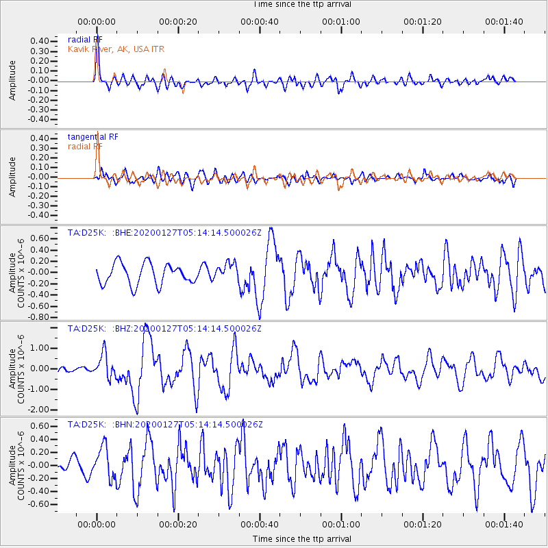
D25K Kavik River, AK, USA - Earthquake Result Viewer
*The percent match for this event was below the threshold and hence no stack was calculated.
| Earthquake location: |
Solomon Islands |
| Earthquake latitude/longitude: |
-10.1/161.0 |
| Earthquake time(UTC): |
2020/01/27 (027) 05:02:01 GMT |
| Earthquake Depth: |
18 km |
| Earthquake Magnitude: |
6.3 Mww |
| Earthquake Catalog/Contributor: |
NEIC PDE/us |
|
| Network: |
TA USArray Transportable Network (new EarthScope stations) |
| Station: |
D25K Kavik River, AK, USA |
| Lat/Lon: |
69.32 N/146.38 W |
| Elevation: |
770 m |
|
| Distance: |
87.2 deg |
| Az: |
16.411 deg |
| Baz: |
231.556 deg |
| Ray Param: |
$rayparam |
*The percent match for this event was below the threshold and hence was not used in the summary stack. |
|
| Radial Match: |
79.47537 % |
| Radial Bump: |
400 |
| Transverse Match: |
66.100464 % |
| Transverse Bump: |
400 |
| SOD ConfigId: |
20465011 |
| Insert Time: |
2020-02-10 05:14:57.808 +0000 |
| GWidth: |
2.5 |
| Max Bumps: |
400 |
| Tol: |
0.001 |
|
Signal To Noise
| Channel | StoN | STA | LTA |
| TA:D25K: :BHZ:20200127T05:14:14.500026Z | 2.9043994 | 6.019669E-7 | 2.0726037E-7 |
| TA:D25K: :BHN:20200127T05:14:14.500026Z | 1.6947441 | 2.4717855E-7 | 1.4585008E-7 |
| TA:D25K: :BHE:20200127T05:14:14.500026Z | 0.87592494 | 1.6101178E-7 | 1.8381915E-7 |
| Arrivals |
| Ps | |
| PpPs | |
| PsPs/PpSs | |


