You are here: Home > Network List > TA - USArray Transportable Network (new EarthScope stations) Stations List
> Station F14K Arctic Creek, AK, USA > Earthquake Result Viewer
F14K Arctic Creek, AK, USA - Earthquake Result Viewer
| Earthquake location: |
Solomon Islands |
| Earthquake latitude/longitude: |
-10.1/161.0 |
| Earthquake time(UTC): |
2020/01/27 (027) 05:02:01 GMT |
| Earthquake Depth: |
18 km |
| Earthquake Magnitude: |
6.3 Mww |
| Earthquake Catalog/Contributor: |
NEIC PDE/us |
|
| Network: |
TA USArray Transportable Network (new EarthScope stations) |
| Station: |
F14K Arctic Creek, AK, USA |
| Lat/Lon: |
65.47 N/166.33 W |
| Elevation: |
266 m |
|
| Distance: |
79.2 deg |
| Az: |
13.253 deg |
| Baz: |
212.739 deg |
| Ray Param: |
0.04912721 |
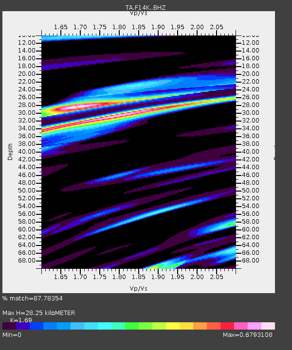
| Estimated Moho Depth: |
28.25 km |
| Estimated Crust Vp/Vs: |
1.69 |
| Assumed Crust Vp: |
6.307 km/s |
| Estimated Crust Vs: |
3.732 km/s |
| Estimated Crust Poisson's Ratio: |
0.23 |
|
| Radial Match: |
87.78354 % |
| Radial Bump: |
400 |
| Transverse Match: |
74.11667 % |
| Transverse Bump: |
400 |
| SOD ConfigId: |
20465011 |
| Insert Time: |
2020-02-10 05:15:15.771 +0000 |
| GWidth: |
2.5 |
| Max Bumps: |
400 |
| Tol: |
0.001 |
|
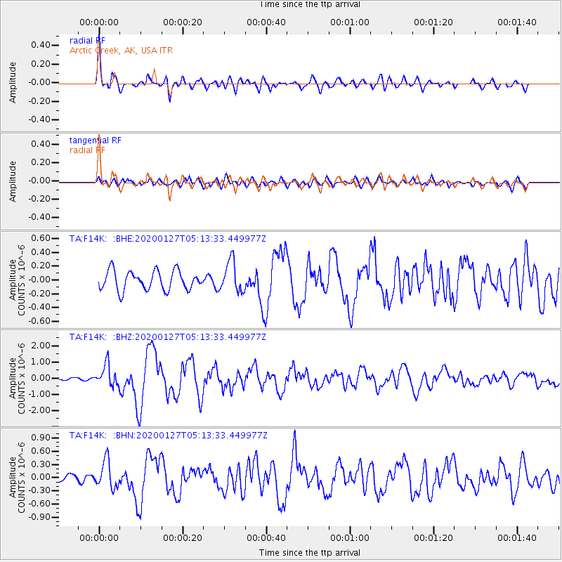
Signal To Noise
| Channel | StoN | STA | LTA |
| TA:F14K: :BHZ:20200127T05:13:33.449977Z | 3.2687087 | 6.793666E-7 | 2.0783943E-7 |
| TA:F14K: :BHN:20200127T05:13:33.449977Z | 4.784938 | 3.1761093E-7 | 6.6377225E-8 |
| TA:F14K: :BHE:20200127T05:13:33.449977Z | 1.6366522 | 2.2809952E-7 | 1.3936958E-7 |
| Arrivals |
| Ps | 3.2 SECOND |
| PpPs | 12 SECOND |
| PsPs/PpSs | 15 SECOND |


