You are here: Home > Network List > TA - USArray Transportable Network (new EarthScope stations) Stations List
> Station G19K Purcell Mountains, AK, USA > Earthquake Result Viewer
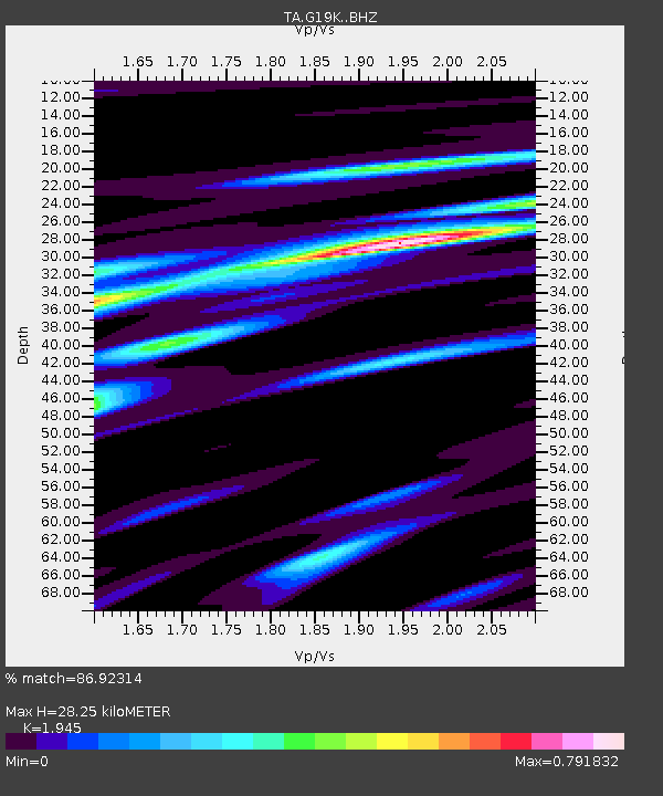
G19K Purcell Mountains, AK, USA - Earthquake Result Viewer
| Earthquake location: |
Solomon Islands |
| Earthquake latitude/longitude: |
-10.1/161.0 |
| Earthquake time(UTC): |
2020/01/27 (027) 05:02:01 GMT |
| Earthquake Depth: |
18 km |
| Earthquake Magnitude: |
6.3 Mww |
| Earthquake Catalog/Contributor: |
NEIC PDE/us |
|
| Network: |
TA USArray Transportable Network (new EarthScope stations) |
| Station: |
G19K Purcell Mountains, AK, USA |
| Lat/Lon: |
66.14 N/157.09 W |
| Elevation: |
391 m |
|
| Distance: |
82.0 deg |
| Az: |
15.916 deg |
| Baz: |
221.598 deg |
| Ray Param: |
0.047167085 |
| Estimated Moho Depth: |
28.25 km |
| Estimated Crust Vp/Vs: |
1.95 |
| Assumed Crust Vp: |
6.577 km/s |
| Estimated Crust Vs: |
3.381 km/s |
| Estimated Crust Poisson's Ratio: |
0.32 |
|
| Radial Match: |
86.92314 % |
| Radial Bump: |
332 |
| Transverse Match: |
72.776825 % |
| Transverse Bump: |
400 |
| SOD ConfigId: |
20465011 |
| Insert Time: |
2020-02-10 05:15:38.422 +0000 |
| GWidth: |
2.5 |
| Max Bumps: |
400 |
| Tol: |
0.001 |
|

Signal To Noise
| Channel | StoN | STA | LTA |
| TA:G19K: :BHZ:20200127T05:13:48.600001Z | 7.909525 | 1.0679709E-6 | 1.350234E-7 |
| TA:G19K: :BHN:20200127T05:13:48.600001Z | 2.1549642 | 3.5049612E-7 | 1.626459E-7 |
| TA:G19K: :BHE:20200127T05:13:48.600001Z | 4.399026 | 4.2597043E-7 | 9.683289E-8 |
| Arrivals |
| Ps | 4.2 SECOND |
| PpPs | 12 SECOND |
| PsPs/PpSs | 16 SECOND |


