You are here: Home > Network List > TA - USArray Transportable Network (new EarthScope stations) Stations List
> Station G23K Bananza Creek, AK, USA > Earthquake Result Viewer
G23K Bananza Creek, AK, USA - Earthquake Result Viewer
| Earthquake location: |
Solomon Islands |
| Earthquake latitude/longitude: |
-10.1/161.0 |
| Earthquake time(UTC): |
2020/01/27 (027) 05:02:01 GMT |
| Earthquake Depth: |
18 km |
| Earthquake Magnitude: |
6.3 Mww |
| Earthquake Catalog/Contributor: |
NEIC PDE/us |
|
| Network: |
TA USArray Transportable Network (new EarthScope stations) |
| Station: |
G23K Bananza Creek, AK, USA |
| Lat/Lon: |
66.71 N/150.02 W |
| Elevation: |
746 m |
|
| Distance: |
84.4 deg |
| Az: |
17.535 deg |
| Baz: |
228.257 deg |
| Ray Param: |
0.04548269 |
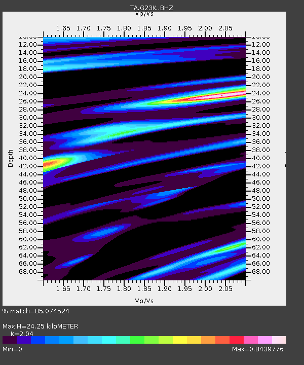
| Estimated Moho Depth: |
24.25 km |
| Estimated Crust Vp/Vs: |
2.04 |
| Assumed Crust Vp: |
6.577 km/s |
| Estimated Crust Vs: |
3.224 km/s |
| Estimated Crust Poisson's Ratio: |
0.34 |
|
| Radial Match: |
85.074524 % |
| Radial Bump: |
400 |
| Transverse Match: |
61.188507 % |
| Transverse Bump: |
400 |
| SOD ConfigId: |
20465011 |
| Insert Time: |
2020-02-10 05:15:41.596 +0000 |
| GWidth: |
2.5 |
| Max Bumps: |
400 |
| Tol: |
0.001 |
|
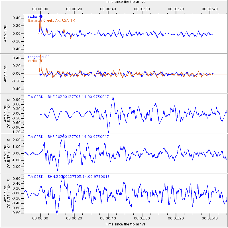
Signal To Noise
| Channel | StoN | STA | LTA |
| TA:G23K: :BHZ:20200127T05:14:00.975001Z | 4.152646 | 7.043512E-7 | 1.6961503E-7 |
| TA:G23K: :BHN:20200127T05:14:00.975001Z | 1.3513916 | 1.9021952E-7 | 1.4075826E-7 |
| TA:G23K: :BHE:20200127T05:14:00.975001Z | 1.0924263 | 1.8864296E-7 | 1.7268255E-7 |
| Arrivals |
| Ps | 3.9 SECOND |
| PpPs | 11 SECOND |
| PsPs/PpSs | 15 SECOND |


