You are here: Home > Network List > TA - USArray Transportable Network (new EarthScope stations) Stations List
> Station H17K Granite Mountain, AK, USA > Earthquake Result Viewer
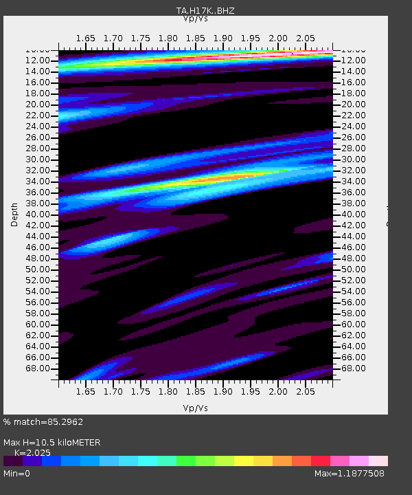
H17K Granite Mountain, AK, USA - Earthquake Result Viewer
| Earthquake location: |
Solomon Islands |
| Earthquake latitude/longitude: |
-10.1/161.0 |
| Earthquake time(UTC): |
2020/01/27 (027) 05:02:01 GMT |
| Earthquake Depth: |
18 km |
| Earthquake Magnitude: |
6.3 Mww |
| Earthquake Catalog/Contributor: |
NEIC PDE/us |
|
| Network: |
TA USArray Transportable Network (new EarthScope stations) |
| Station: |
H17K Granite Mountain, AK, USA |
| Lat/Lon: |
64.94 N/159.91 W |
| Elevation: |
396 m |
|
| Distance: |
80.3 deg |
| Az: |
15.801 deg |
| Baz: |
219.011 deg |
| Ray Param: |
0.04833929 |
| Estimated Moho Depth: |
10.5 km |
| Estimated Crust Vp/Vs: |
2.03 |
| Assumed Crust Vp: |
6.1 km/s |
| Estimated Crust Vs: |
3.012 km/s |
| Estimated Crust Poisson's Ratio: |
0.34 |
|
| Radial Match: |
85.2962 % |
| Radial Bump: |
316 |
| Transverse Match: |
81.805626 % |
| Transverse Bump: |
400 |
| SOD ConfigId: |
20465011 |
| Insert Time: |
2020-02-10 05:15:47.902 +0000 |
| GWidth: |
2.5 |
| Max Bumps: |
400 |
| Tol: |
0.001 |
|

Signal To Noise
| Channel | StoN | STA | LTA |
| TA:H17K: :BHZ:20200127T05:13:39.675014Z | 3.295913 | 8.653584E-7 | 2.62555E-7 |
| TA:H17K: :BHN:20200127T05:13:39.675014Z | 1.7413514 | 2.0447959E-7 | 1.1742581E-7 |
| TA:H17K: :BHE:20200127T05:13:39.675014Z | 2.4096594 | 2.669524E-7 | 1.107843E-7 |
| Arrivals |
| Ps | 1.8 SECOND |
| PpPs | 5.1 SECOND |
| PsPs/PpSs | 6.9 SECOND |


