You are here: Home > Network List > TS - TERRAscope (Southern California Seismic Network) Stations List
> Station PFO Pinon Flat, California, USA > Earthquake Result Viewer
PFO Pinon Flat, California, USA - Earthquake Result Viewer
| Earthquake location: |
Off Coast Of Southern Chile |
| Earthquake latitude/longitude: |
-40.3/-74.9 |
| Earthquake time(UTC): |
1998/04/01 (091) 22:42:56 GMT |
| Earthquake Depth: |
9.0 km |
| Earthquake Magnitude: |
6.2 MB, 6.0 MS, 6.7 UNKNOWN, 6.6 ME |
| Earthquake Catalog/Contributor: |
WHDF/NEIC |
|
| Network: |
TS TERRAscope (Southern California Seismic Network) |
| Station: |
PFO Pinon Flat, California, USA |
| Lat/Lon: |
33.61 N/116.46 W |
| Elevation: |
1280 m |
|
| Distance: |
83.0 deg |
| Az: |
326.079 deg |
| Baz: |
149.249 deg |
| Ray Param: |
0.04651363 |
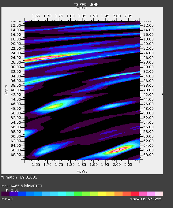
| Estimated Moho Depth: |
65.5 km |
| Estimated Crust Vp/Vs: |
2.01 |
| Assumed Crust Vp: |
6.264 km/s |
| Estimated Crust Vs: |
3.116 km/s |
| Estimated Crust Poisson's Ratio: |
0.34 |
|
| Radial Match: |
89.31033 % |
| Radial Bump: |
400 |
| Transverse Match: |
75.21532 % |
| Transverse Bump: |
400 |
| SOD ConfigId: |
4480 |
| Insert Time: |
2010-02-26 14:41:15.718 +0000 |
| GWidth: |
2.5 |
| Max Bumps: |
400 |
| Tol: |
0.001 |
|
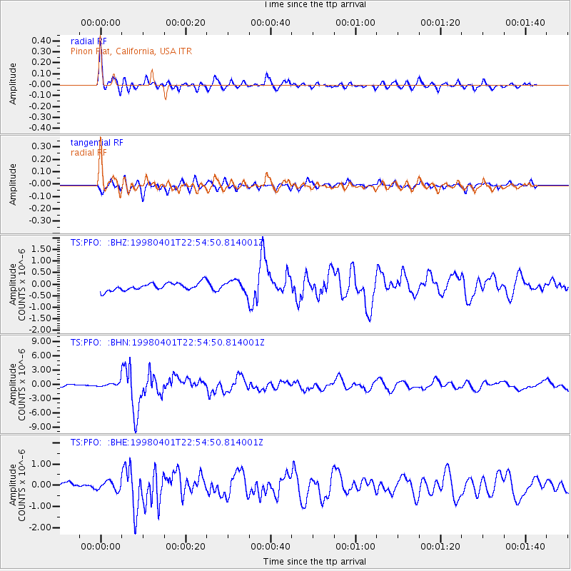
Signal To Noise
| Channel | StoN | STA | LTA |
| TS:PFO: :BHN:19980401T22:54:50.814001Z | 2.125143 | 6.2688434E-7 | 2.9498455E-7 |
| TS:PFO: :BHE:19980401T22:54:50.814001Z | 1.0143174 | 2.17454E-7 | 2.1438457E-7 |
| TS:PFO: :BHZ:19980401T22:54:50.814001Z | 1.6839002 | 2.7678212E-7 | 1.6436965E-7 |
| Arrivals |
| Ps | 11 SECOND |
| PpPs | 31 SECOND |
| PsPs/PpSs | 42 SECOND |


