You are here: Home > Network List > TA - USArray Transportable Network (new EarthScope stations) Stations List
> Station M11K Mekoryuk, AK, USA > Earthquake Result Viewer
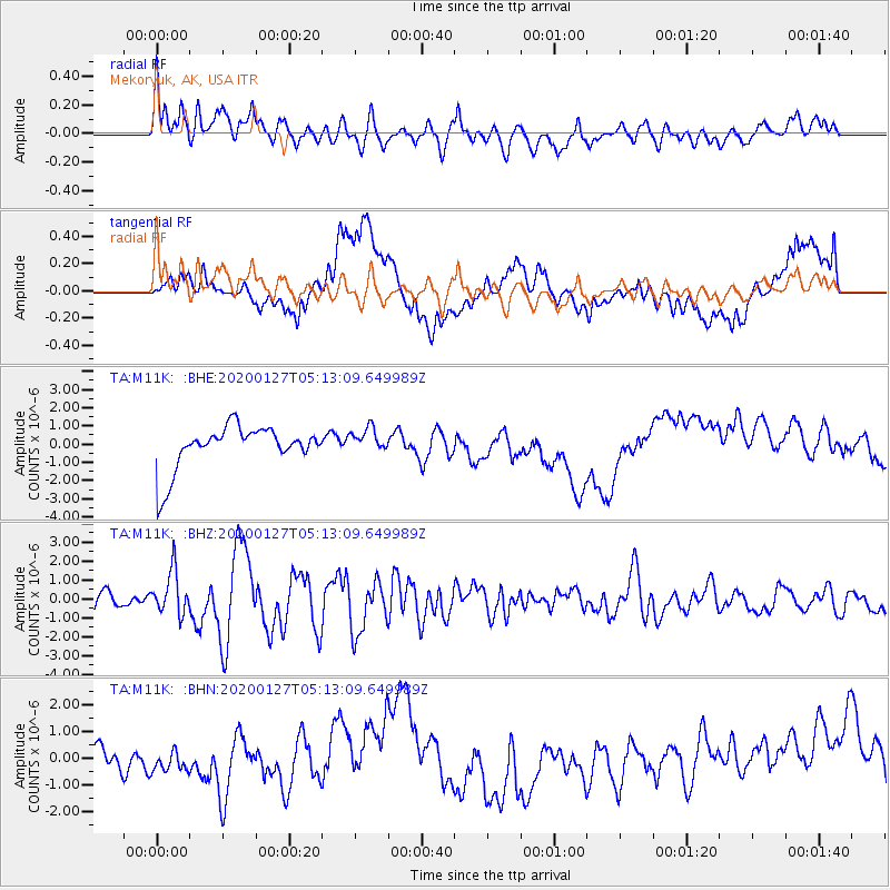
M11K Mekoryuk, AK, USA - Earthquake Result Viewer
*The percent match for this event was below the threshold and hence no stack was calculated.
| Earthquake location: |
Solomon Islands |
| Earthquake latitude/longitude: |
-10.1/161.0 |
| Earthquake time(UTC): |
2020/01/27 (027) 05:02:01 GMT |
| Earthquake Depth: |
18 km |
| Earthquake Magnitude: |
6.3 Mww |
| Earthquake Catalog/Contributor: |
NEIC PDE/us |
|
| Network: |
TA USArray Transportable Network (new EarthScope stations) |
| Station: |
M11K Mekoryuk, AK, USA |
| Lat/Lon: |
60.38 N/166.20 W |
| Elevation: |
3.0 m |
|
| Distance: |
74.9 deg |
| Az: |
16.167 deg |
| Baz: |
213.506 deg |
| Ray Param: |
$rayparam |
*The percent match for this event was below the threshold and hence was not used in the summary stack. |
|
| Radial Match: |
67.159355 % |
| Radial Bump: |
400 |
| Transverse Match: |
27.579754 % |
| Transverse Bump: |
400 |
| SOD ConfigId: |
20465011 |
| Insert Time: |
2020-02-10 05:16:22.690 +0000 |
| GWidth: |
2.5 |
| Max Bumps: |
400 |
| Tol: |
0.001 |
|
Signal To Noise
| Channel | StoN | STA | LTA |
| TA:M11K: :BHZ:20200127T05:13:09.649989Z | 2.8301773 | 1.1435498E-6 | 4.040559E-7 |
| TA:M11K: :BHN:20200127T05:13:09.649989Z | 0.7723812 | 4.5878713E-7 | 5.9399053E-7 |
| TA:M11K: :BHE:20200127T05:13:09.649989Z | 0.58595896 | 7.0445384E-7 | 1.2022239E-6 |
| Arrivals |
| Ps | |
| PpPs | |
| PsPs/PpSs | |


